IMAGES TAKEN NEAR TO
Fereneze Drive, PAISLEY, PA2 8NL
Introduction
This page details the photographs taken nearby to Fereneze Drive, PA2 8NL by members of the Geograph project.
The Geograph project started in 2005 with the aim of publishing, organising and preserving representative images for every square kilometre of Great Britain, Ireland and the Isle of Man.

There are currently over 7.5m images from over14,400 individuals and you can help contribute to the project by visiting https://www.geograph.org.uk
Image Map
Images are licensed for reuse under creativecommons.org/licenses/by-sa/2.0
Notes
- Clicking on the map will re-center to the selected point.
- The higher the marker number, the further away the image location is from the centre of the postcode.
Image Listing (66 Images Found)
Images are licensed for reuse under creativecommons.org/licenses/by-sa/2.0
Image
Details
Distance
1
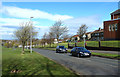
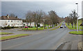
Glenburn Road, Paisley
Viewed on a bright early-May Saturday morning.
Image: © Mary and Angus Hogg
Taken: 4 May 2013
0.10 miles
2
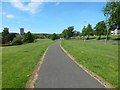
Cycle path beside Glenburn Road
Glenburn Road itself can be seen on the right. The two tower blocks in the left background are Nethercraigs Court at Image and (to its right) Gleniffer Court at Image
The cycle path itself is part of the Image (that view is from a point 960 metres to ESE, or, in relation to the present picture, nearly a kilometre behind the photographer's position).
Image: © Lairich Rig
Taken: 31 May 2017
0.11 miles
3
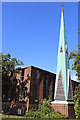
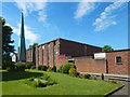
Glenburn Parish Church, Craigiebar Drive, Paisley
Image: © Leslie Barrie
Taken: 9 Jul 2014
0.12 miles
4
Nethercraigs Drive, Paisley
My attention was drawn this way by the seemingly-detached spire with the verdigris patina: it belongs to Image; see also the earlier picture Image
Image: © Lairich Rig
Taken: 31 May 2017
0.12 miles
5
Glenburn Parish Church
The surroundings conspire to make it difficult to get an unobstructed view of the church as a whole, but the freestanding spire, which is what drew my attention to the building, is shown from another angle in an earlier picture: Image
The building stands on a square of land bounded by Nethercraigs Drive (SE), Craigiebar Drive (SW & NW), and Mossneuk Drive (NE). The architect was James Houston, who died in 1966. According to the official website for the church, the foundation stone was laid in 1961, and the church opened in the following year.
For context, see Image, showing the setting.
Image: © Lairich Rig
Taken: 31 May 2017
0.12 miles
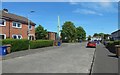
7
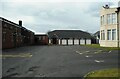
Church hall, St Peter's Roman Catholic Church
The church hall opened in 2003.
Image: © Richard Sutcliffe
Taken: 14 Apr 2023
0.13 miles
8
St Peter's Church,Glenburn
Sitting on corner of Braehead Road/ Glenburn Road.
Image: © wfmillar
Taken: 29 Mar 2011
0.14 miles
9
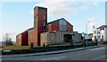
St Peter's Roman Catholic Church
The church is located beside Braehead Road, near a roundabout that is at the intersection of that road and Glenburn Road.
Image: © Lairich Rig
Taken: 28 Feb 2011
0.14 miles
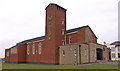
10
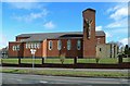
St Peter's Church
This prominent modern building is located in Paisley's Glenburn Road.
Image: © Mary and Angus Hogg
Taken: 4 May 2013
0.14 miles