IMAGES TAKEN NEAR TO
Craigendon Oval, PAISLEY, PA2 8JT
Introduction
This page details the photographs taken nearby to Craigendon Oval, PA2 8JT by members of the Geograph project.
The Geograph project started in 2005 with the aim of publishing, organising and preserving representative images for every square kilometre of Great Britain, Ireland and the Isle of Man.

There are currently over 7.5m images from over14,400 individuals and you can help contribute to the project by visiting https://www.geograph.org.uk
Image Map
Images are licensed for reuse under creativecommons.org/licenses/by-sa/2.0
Notes
- Clicking on the map will re-center to the selected point.
- The higher the marker number, the further away the image location is from the centre of the postcode.
Image Listing (35 Images Found)
Images are licensed for reuse under creativecommons.org/licenses/by-sa/2.0
Image
Details
Distance
2
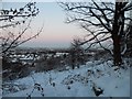
A view through the trees
Looking through the bare trees towards the southern edge of Paisley. This view will disappear once the trees come into leaf.
Image: © Richard Sutcliffe
Taken: 14 Apr 2023
0.11 miles
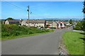
3
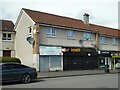
Shops on Braehead Road
CL Photography and Doner n Shake (a fast food restaurant).
Image: © Richard Sutcliffe
Taken: 14 Apr 2023
0.14 miles
4
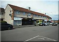
Shops on Braehead Road
The shops include a photographer's, fast food restaurant and a Spar.
Image: © Richard Sutcliffe
Taken: 14 Apr 2023
0.14 miles
5
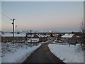
Glenburn, Paisley
From Braehead Road.
Image: © Stephen Sweeney
Taken: 2 Dec 2010
0.15 miles
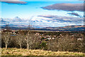
6
Braehead Road, Paisley
A view in the opposite direction, and in a different season, from a little further up the road makes for a striking contrast: Image
In the present picture, the descending road is crossed, not far ahead, by another road, which is called Hillcrest Avenue to the left of the junction, and Craigmount Avenue to the right.
For an earlier and more wintry equivalent of the present picture, see Image
In the present picture, a little bump on the rightmost part of the skyline is Dumgoyne (Image), about 23km (14 miles) away.
Flanking the near side of the junction just ahead, there is a wooden pole (left) and a lamp post (right). The noticeable dip on the skyline about midway between pole and lamp post corresponds to a gap (at Image) between the Slacks, to the left, and Cochno Hill, to the right. Greenside Reservoir occupies that lower ground.
A similar dip just to the right of the lamp post corresponds to the gap (Image) between Cochno Hill and the Birny Hills, occupied by Cochno Loch and the Jaw Reservoir.
Image: © Lairich Rig
Taken: 31 May 2017
0.16 miles
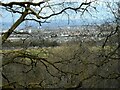
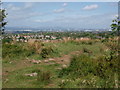
7
River Clyde and Dumbarton Rock from Glen Park, Paisley
Image: © Robert Purdie
Taken: 14 Feb 2022
0.17 miles
8
Remains of a boundary
In the foreground, the low remains of a dry-stone wall cross the path. This boundary is shown on the first-edition OS map (surveyed 1858). About 130 metres to the east is another, likewise shown on the 1858 map, similar to this one in appearance, and running parallel to it, heading roughly north from the middle of Upper Glen Dam.
Image: © Lairich Rig
Taken: 4 May 2019
0.18 miles
9
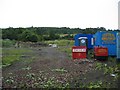
Demolition of Glenfield Cattle Market
The final part of the old cattle market at Glenfield is now being demolished to make way for new housing.
Image: © John Allan
Taken: 2 Aug 2006
0.18 miles
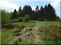
10
Path on Gleniffer Braes
Gleniffer Braes are covered in paths worn by traffic. This one goes through a gap, no doubt a gate, in an old wall now covered and barely perceptible.
Image: © Alec MacKinnon
Taken: 25 May 2016
0.19 miles