IMAGES TAKEN NEAR TO
Lismore Drive, PAISLEY, PA2 8HY
Introduction
This page details the photographs taken nearby to Lismore Drive, PA2 8HY by members of the Geograph project.
The Geograph project started in 2005 with the aim of publishing, organising and preserving representative images for every square kilometre of Great Britain, Ireland and the Isle of Man.

There are currently over 7.5m images from over14,400 individuals and you can help contribute to the project by visiting https://www.geograph.org.uk
Image Map
Images are licensed for reuse under creativecommons.org/licenses/by-sa/2.0
Notes
- Clicking on the map will re-center to the selected point.
- The higher the marker number, the further away the image location is from the centre of the postcode.
Image Listing (8 Images Found)
Images are licensed for reuse under creativecommons.org/licenses/by-sa/2.0
Image
Details
Distance
1
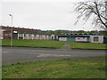
Glenburn Health Centre and Glenburn Library
On Fairway Avenue, Glenburn, Paisley.
Image: © G Laird
Taken: 25 Apr 2014
0.17 miles
2
Speed camera on Glenburn Road Paisley
Pictured 30th July 2009 7.55p.m.
Image: © Gordon Dowie
Taken: 30 Jul 2009
0.18 miles
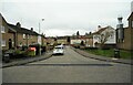
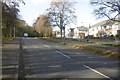
4
Glenburn Road
The through road version of Glenburn Road on the left is separated from the residnetial Glenburn Road on the right by a grassy strip with trees.
Image: © Richard Sutcliffe
Taken: 23 Feb 2023
0.20 miles
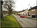
5
Glenburn Road
To the left is woodland on former industrial land.
Image: © Richard Webb
Taken: 6 Nov 2016
0.21 miles
6
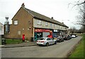
Shops, Sanda Way
The large chimney belongs to iEat, a Chinese takeaway.
Image: © Richard Sutcliffe
Taken: 23 Feb 2023
0.21 miles
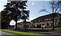
7
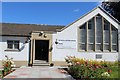
Glenburn Baptist Church, Braehead Road, Paisley
Image: © Leslie Barrie
Taken: 9 Jul 2014
0.24 miles
8
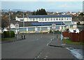
St Peter's Primary School
Primary school in Glenburn, Paisley. Originally built in the 1950s, the solar panels on the roofs are much more recent.
Image: © Richard Sutcliffe
Taken: 14 Apr 2023
0.25 miles