IMAGES TAKEN NEAR TO
Grampian Avenue, PAISLEY, PA2 8DN
Introduction
This page details the photographs taken nearby to Grampian Avenue, PA2 8DN by members of the Geograph project.
The Geograph project started in 2005 with the aim of publishing, organising and preserving representative images for every square kilometre of Great Britain, Ireland and the Isle of Man.

There are currently over 7.5m images from over14,400 individuals and you can help contribute to the project by visiting https://www.geograph.org.uk
Image Map
Images are licensed for reuse under creativecommons.org/licenses/by-sa/2.0
Notes
- Clicking on the map will re-center to the selected point.
- The higher the marker number, the further away the image location is from the centre of the postcode.
Image Listing (27 Images Found)
Images are licensed for reuse under creativecommons.org/licenses/by-sa/2.0
Image
Details
Distance
1
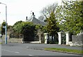
Blacklands Lodge and gate piers
Unfortunately this Category B listed lodge https://portal.historicenvironment.scot/designation/LB38954 on Donaldswood Road dating from about 1800, is almost invisible due to the growth of vegetation around it.
Image: © Richard Sutcliffe
Taken: 14 Apr 2023
0.13 miles
2
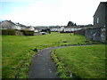
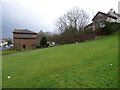
Green space behind houses
Amenity grassland behind Fairway Avenue (on the left) and Denewood Avenue (in the distance).
Image: © Richard Sutcliffe
Taken: 14 Apr 2023
0.13 miles
3
Glenburn Health Centre and Glenburn Library
On Fairway Avenue, Glenburn, Paisley.
Image: © G Laird
Taken: 25 Apr 2014
0.18 miles
4
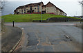
Moorfoot Avenue
Viewed across Falside Road from Stanely Drive.
Image: © Thomas Nugent
Taken: 29 Feb 2016
0.19 miles
5
Course of the Potterhill Branch railway
The Glasgow & South Western Railway line ran approximately where the cars are parked near the centre of the photo. Falside Road is on the left.
Image: © Thomas Nugent
Taken: 29 Feb 2016
0.20 miles
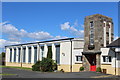
6
St Peter's Primary School
Primary school in Glenburn, Paisley. Originally built in the 1950s.
Image: © Richard Sutcliffe
Taken: 14 Apr 2023
0.21 miles
7
St Peter's Primary School, Braehead Road, Paisley
Image: © Leslie Barrie
Taken: 9 Jul 2014
0.21 miles
8
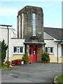
Main entrance, St Peter's Primary School
The distinctive entrance to the school, dating from the 1950s.
Image: © Richard Sutcliffe
Taken: 14 Apr 2023
0.21 miles
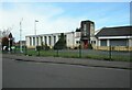
9
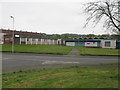
Blacklandmill Bowling Club
Bowling Club on Braehead Road.
Image: © Richard Sutcliffe
Taken: 14 Apr 2023
0.22 miles
10
St Peter's Primary School
Primary school in Glenburn, Paisley. Originally built in the 1950s, the solar panels on the roofs are much more recent.
Image: © Richard Sutcliffe
Taken: 14 Apr 2023
0.22 miles