IMAGES TAKEN NEAR TO
Crestlea Avenue, PAISLEY, PA2 8BG
Introduction
This page details the photographs taken nearby to Crestlea Avenue, PA2 8BG by members of the Geograph project.
The Geograph project started in 2005 with the aim of publishing, organising and preserving representative images for every square kilometre of Great Britain, Ireland and the Isle of Man.

There are currently over 7.5m images from over14,400 individuals and you can help contribute to the project by visiting https://www.geograph.org.uk
Image Map
Images are licensed for reuse under creativecommons.org/licenses/by-sa/2.0
Notes
- Clicking on the map will re-center to the selected point.
- The higher the marker number, the further away the image location is from the centre of the postcode.
Image Listing (41 Images Found)
Images are licensed for reuse under creativecommons.org/licenses/by-sa/2.0
Image
Details
Distance
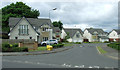
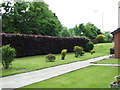
2
Lapsley Avenue
This photograph of a fairly recent housing development, Lapsley Avenue, was taken from Neilston Road, which appears on the right.
Image: © Lairich Rig
Taken: 28 Feb 2011
0.08 miles
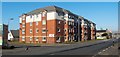
3
Lapsley Avenue, Paisley
Modern flats and houses in Paisley's Lapsley Avenue.
Image: © Mary and Angus Hogg
Taken: 4 May 2013
0.08 miles
4
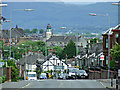
Neilston Road
Looking over the town from Thornly Park Drive to the Kilpatrick Hills. The 7Km distant Inchinnan church can be seen to the right of centre, under the overhang of the lamppost.
Image: © Thomas Nugent
Taken: 14 Jun 2013
0.10 miles
5

Neilston Road, Paisley
Looking north, towards the town centre.
Image: © Thomas Nugent
Taken: 18 May 2006
0.10 miles
6
Former railway bridge and trackbed
Near the former Potterton station, where the former Paisley to Barrhead line passed under Neilston Road. The metal parapet is screened by the long hedge. See the road side of the parapet here Image
Image: © Thomas Nugent
Taken: 14 Jun 2013
0.13 miles
7
Former railway bridge on Neilston Road
Near the former Potterton station, where the former Paisley to Barrhead line passed under Neilston Road. See the other side of the parapet here Image
Image: © Thomas Nugent
Taken: 14 Jun 2013
0.13 miles
8
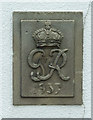
Date stone on Neilston Road
On the telephone exchange on Neilston Road Image
Image: © Thomas Nugent
Taken: 14 Jun 2013
0.14 miles
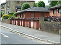
9
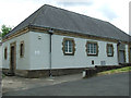
Telephone exchange Neilston Road
The former Thornly Park exchange is still in use, but is no longer known by that name. The area is served by 0141 884 XXXX numbers. The building has a G vi R 1937 date stone Image
Image: © Thomas Nugent
Taken: 14 Jun 2013
0.14 miles
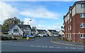
10
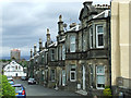
Neilston Road
A row of terraced villas set back from the main road.
Image: © Thomas Nugent
Taken: 14 Jun 2013
0.15 miles