IMAGES TAKEN NEAR TO
Southend, CAMPBELTOWN, PA28 6RG
Introduction
This page details the photographs taken nearby to PA28 6RG by members of the Geograph project.
The Geograph project started in 2005 with the aim of publishing, organising and preserving representative images for every square kilometre of Great Britain, Ireland and the Isle of Man.

There are currently over 7.5m images from over14,400 individuals and you can help contribute to the project by visiting https://www.geograph.org.uk
Image Map
Images are licensed for reuse under creativecommons.org/licenses/by-sa/2.0
Notes
- Clicking on the map will re-center to the selected point.
- The higher the marker number, the further away the image location is from the centre of the postcode.
Image Listing (3 Images Found)
Images are licensed for reuse under creativecommons.org/licenses/by-sa/2.0
Image
Details
Distance
1
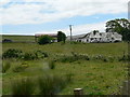
Pennyland
Pennyland farm, former home of the McDonalds in Southend. There was a mill and smithy.
Image: © Harold Ralston
Taken: 10 Jun 1990
0.01 miles
2
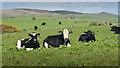
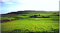
Livestock at Pennyland
Spring took a long time to arrive in Kintyre this year and the cattle seem to appreciate the outdoors and new grass all the more for it.
Image: © Steve Partridge
Taken: 28 May 2015
0.03 miles