IMAGES TAKEN NEAR TO
Carradale, CAMPBELTOWN, PA28 6QL
Introduction
This page details the photographs taken nearby to PA28 6QL by members of the Geograph project.
The Geograph project started in 2005 with the aim of publishing, organising and preserving representative images for every square kilometre of Great Britain, Ireland and the Isle of Man.

There are currently over 7.5m images from over14,400 individuals and you can help contribute to the project by visiting https://www.geograph.org.uk
Image Map
Images are licensed for reuse under creativecommons.org/licenses/by-sa/2.0
Notes
- Clicking on the map will re-center to the selected point.
- The higher the marker number, the further away the image location is from the centre of the postcode.
Image Listing (8 Images Found)
Images are licensed for reuse under creativecommons.org/licenses/by-sa/2.0
Image
Details
Distance
1
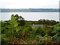
Looking down on Sunadale Cottage
Kilbrannan Sound and Arran beyond. The cloud is sitting low on the Arran hills.
Image: © Gordon Brown
Taken: 24 Sep 2013
0.00 miles
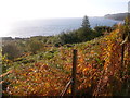
3
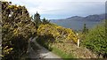
Drive, Sunadale Cottage
Woodland on the east side of Kintyre with a view of northwest Arran.
Image: © Richard Webb
Taken: 29 Apr 2012
0.06 miles
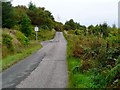
4
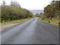
Road (B842) near to Sunadale Cottage
Looking south-westward.
Image: © Peter Wood
Taken: 1 Apr 2019
0.08 miles
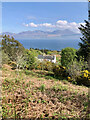
6
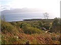
Sunadale by Grogport, Kintyre
Looking east from the B842 to the Eilean (island) Sunadale with the hills of Arran in the background.
Image: © Johnny Durnan
Taken: 8 Oct 2005
0.12 miles
7
Sunadale by Grogport, Kintyre.
Sunadale on the B842 looking south towards Carradale, Kintyre.
Image: © Johnny Durnan
Taken: 8 Oct 2005
0.18 miles
8
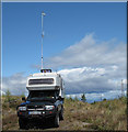
Off Road Office
Parked up just off the B842 on Kintyre, the Off Road Office (and Geograph bagging vehicle) attempting to upload Geograph data via mobile connection.
Power lines and Arran in the background.
Image: © Chris N Illingworth
Taken: 9 Sep 2009
0.21 miles