IMAGES TAKEN NEAR TO
CAMPBELTOWN, PA28 6NX
Introduction
This page details the photographs taken nearby to PA28 6NX by members of the Geograph project.
The Geograph project started in 2005 with the aim of publishing, organising and preserving representative images for every square kilometre of Great Britain, Ireland and the Isle of Man.

There are currently over 7.5m images from over14,400 individuals and you can help contribute to the project by visiting https://www.geograph.org.uk
Image Map
Images are licensed for reuse under creativecommons.org/licenses/by-sa/2.0
Notes
- Clicking on the map will re-center to the selected point.
- The higher the marker number, the further away the image location is from the centre of the postcode.
Image Listing (5 Images Found)
Images are licensed for reuse under creativecommons.org/licenses/by-sa/2.0
Image
Details
Distance
1
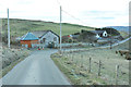
Houses at the roadside near High Ranachan
Image: © Steven Brown
Taken: 12 Mar 2013
0.01 miles
2
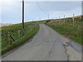
Minor road between Upper Ballywilline and High Ranachan
Looking north-westward.
Image: © Peter Wood
Taken: 5 Apr 2019
0.04 miles
3
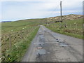
Minor road between Uppert Ballywilline and High Ranachan
Looking north-westward.
Image: © Peter Wood
Taken: 5 Apr 2019
0.12 miles
4
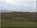
View from High Ranachan
Looking towards Image from the bend in the road near High Ranachan.
Image: © Steve Partridge
Taken: 12 Jan 2006
0.13 miles
5
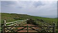
Sheep pen, Ballywilline Hill, Argyll
Unlike many I come across, this sheep pen appears to be still in use.
Image: © Claire Pegrum
Taken: 1 Jun 2021
0.14 miles