IMAGES TAKEN NEAR TO
Davaar Avenue, CAMPBELTOWN, PA28 6NH
Introduction
This page details the photographs taken nearby to Davaar Avenue, PA28 6NH by members of the Geograph project.
The Geograph project started in 2005 with the aim of publishing, organising and preserving representative images for every square kilometre of Great Britain, Ireland and the Isle of Man.

There are currently over 7.5m images from over14,400 individuals and you can help contribute to the project by visiting https://www.geograph.org.uk
Image Map (6 Images)


Leaflet Map data © OpenStreetMap
Images are licensed for reuse under creativecommons.org/licenses/by-sa/2.0
Notes
- Clicking on the map will re-center to the selected point.
- The higher the marker number, the further away the image location is from the centre of the postcode.
Image Listing (6 Images Found)
Images are licensed for reuse under creativecommons.org/licenses/by-sa/2.0
Image
Details
Distance
3
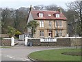
Dellwood Hotel
Junction of Longrow (A83) and High Street, Campbeltown.
Image: © Derek Tootill
Taken: 9 Apr 2010
0.24 miles
4
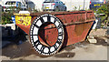
Campbeltown Town Hall Clock Face
One of three, in a local builders yard and about to be renovated.
Image: © Steve Partridge
Taken: 29 Sep 2015
0.24 miles
5
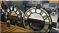
Campbeltown Town Hall Clock Faces
Two of the three clock faces about to reburbished at a local builders.
Image: © Steve Partridge
Taken: 29 Sep 2015
0.24 miles