IMAGES TAKEN NEAR TO
Smith Drive, CAMPBELTOWN, PA28 6LB
Introduction
This page details the photographs taken nearby to Smith Drive, PA28 6LB by members of the Geograph project.
The Geograph project started in 2005 with the aim of publishing, organising and preserving representative images for every square kilometre of Great Britain, Ireland and the Isle of Man.

There are currently over 7.5m images from over14,400 individuals and you can help contribute to the project by visiting https://www.geograph.org.uk
Image Map
Images are licensed for reuse under creativecommons.org/licenses/by-sa/2.0
Notes
- Clicking on the map will re-center to the selected point.
- The higher the marker number, the further away the image location is from the centre of the postcode.
Image Listing (92 Images Found)
Images are licensed for reuse under creativecommons.org/licenses/by-sa/2.0
Image
Details
Distance
1
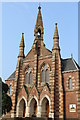
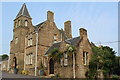
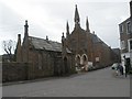
Campbeltown Heritage Centre
Former Lorne Street Free Gaelic Church. Category C-listed. Built 1867. Architect James Boucher of Boucher & Cousland.
Image: © Leslie Barrie
Taken: 12 Jul 2013
0.06 miles
2
Campbeltown Sheriff Court
The Campbeltown Sheriff and District Court on Castlehill, seen from the south.
For more information about the Scottish Courts, see http://www.scotcourts.gov.uk/
Image: © Patrick Mackie
Taken: 10 Jan 2007
0.07 miles
3
Castlehill Mansions, Campbeltown
Category B-listed former Castlehill Church. Built 1778-80. Architect George Haswell, Inveraray. Occupies the site of Kinloch (or Lochhead) Castle, stronghold of the Earls of Argyll, destroyed by General Leslie in 1647. The church has now been converted for residential use.
Image: © Leslie Barrie
Taken: 12 Jul 2013
0.08 miles
4
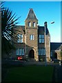
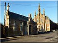
Sheriff Courthouse, Castlehill, Campbeltown
Category B-listed. Built 1869-71. Architect David Cousin, Edinburgh
Image: © Leslie Barrie
Taken: 12 Jul 2013
0.08 miles
5
Sheriff Courthouse, Castlehill, Campbeltown
Category B-listed. Built 1869-71. Architect David Cousin, Edinburgh
Image: © Leslie Barrie
Taken: 12 Jul 2013
0.08 miles
6
Campbeltown Backpackers Hostel & Heritage Centre
The new Campbeltown bunkhouse, opened in April 2012, is housed in the newly refurbished Old Schoolhouse, a Grade B listed building. We where one of the first groups to use this new hostel at the end of April 2012 with its handy central location and good car park.
Image: © Rude Health
Taken: 29 Apr 2012
0.08 miles
7
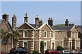
Campbeltown - Houses in Witchburn Road
Image: © James Emmans
Taken: 25 Sep 2016
0.08 miles
8
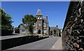
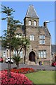
Sheriff Court and Justice of the Peace Court, Campbeltown, Argyll
The courthouse is a category C listed building. Its listing at http://portal.historicenvironment.scot/designation/LB43057 says that it is, "a good example of burgh civic architecture. Designed by David Cousin in the 1860s, it is a relatively unusual adaptation of the Franco-Gothic architectural style which became popular in the mid-19th century for country house design but was less commonly used for public buildings."
Image: © Claire Pegrum
Taken: 30 May 2021
0.09 miles
9
Old school hall, Campbeltown
The Campbeltown Heritage Centre (background) occupies the former Lorne Street Church and is a treasure-trove of interesting information, artifacts and exhibits, which depict many aspects of cultural, social, economic and industrial influences which have contributed to the development of this unique town.
Image: © Derek Tootill
Taken: 8 Apr 2010
0.09 miles
10
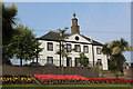
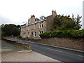
Castlehill, Drumfin & Former Lowland Church Manse, Campbeltown
Category B-listed. Built c1845
Image: © Leslie Barrie
Taken: 12 Jul 2013
0.09 miles