IMAGES TAKEN NEAR TO
Burnside Street, CAMPBELTOWN, PA28 6JE
Introduction
This page details the photographs taken nearby to Burnside Street, PA28 6JE by members of the Geograph project.
The Geograph project started in 2005 with the aim of publishing, organising and preserving representative images for every square kilometre of Great Britain, Ireland and the Isle of Man.

There are currently over 7.5m images from over14,400 individuals and you can help contribute to the project by visiting https://www.geograph.org.uk
Image Map
Images are licensed for reuse under creativecommons.org/licenses/by-sa/2.0
Notes
- Clicking on the map will re-center to the selected point.
- The higher the marker number, the further away the image location is from the centre of the postcode.
Image Listing (205 Images Found)
Images are licensed for reuse under creativecommons.org/licenses/by-sa/2.0
Image
Details
Distance
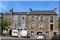
2
The Old School, Campbeltown
A recent Options Appraisal suggests this will be converted into tourist accommodation
Image: © PAUL FARMER
Taken: 26 Sep 2009
0.02 miles
3
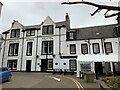
Argyll Arms Hotel, Campbeltown
Category B listed. Listing reference LB43121.
Architect James Weir, circa 1900.
Image: © Andrew Abbott
Taken: 14 Oct 2021
0.03 miles
4
Main Street Campbeltown
From Main street during Music Festival with Campbeltown Pipe Band
Image: © Eddie Mackinnon
Taken: 18 Aug 2006
0.03 miles
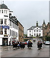
5
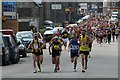
Mull of Kintyre Half Marathon and 10km
About a minute after the start from the seafront. The runners, still a combination of the two races at this point, head up Longrow. I had the privilege of photographing the two races from the rear portion of the timekeeping car. Weatherwise, it was a great day for it; lovely sunshine with a cooling breeze.
Edit: Have you seen the price of diesel on the sign top left corner? That's scandalous!
Image: © Steve Partridge
Taken: 25 May 2008
0.03 miles
6
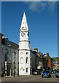
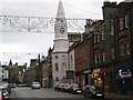
Campbeltown Town Hall
A prominent land mark in the town's Main Street, viewed on a fine mid-September afternoon.
Image: © Mary and Angus Hogg
Taken: 21 Sep 2017
0.04 miles
7

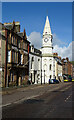
Longrow, Campbeltown
Entering the town on the A83.
Image: © Stephen Sweeney
Taken: 19 Aug 2010
0.04 miles
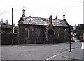
8
Town Hall
The 18th century Town Hall has a distinctive octagonal spire. It is a Category B Listed building. See http://portal.historicenvironment.scot/designation/LB22918 for full details and history.
Image: © Anne Burgess
Taken: 1 Oct 2021
0.04 miles
9
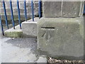
Ordnance Survey Cut Mark
This mark can be found on the wall of the Backpackers' Hostel in Campbeltown. The benchmark height is recorded as 5.455 metres above sea level.
For more detail see : https://www.bench-marks.org.uk/bm102510
Image: © Peter Wood
Taken: 5 Apr 2019
0.04 miles
10
Town Hall Campbeltown
The spired building with clock has just been completely repainted.
Image: © Johnny Durnan
Taken: 25 Nov 2007
0.04 miles