IMAGES TAKEN NEAR TO
Ben Loyal Avenue, PAISLEY, PA2 7NA
Introduction
This page details the photographs taken nearby to Ben Loyal Avenue, PA2 7NA by members of the Geograph project.
The Geograph project started in 2005 with the aim of publishing, organising and preserving representative images for every square kilometre of Great Britain, Ireland and the Isle of Man.

There are currently over 7.5m images from over14,400 individuals and you can help contribute to the project by visiting https://www.geograph.org.uk
Image Map
Images are licensed for reuse under creativecommons.org/licenses/by-sa/2.0
Notes
- Clicking on the map will re-center to the selected point.
- The higher the marker number, the further away the image location is from the centre of the postcode.
Image Listing (43 Images Found)
Images are licensed for reuse under creativecommons.org/licenses/by-sa/2.0
Image
Details
Distance
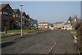
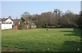
2
Ben Hope Avenue, Hawkhead Estate
The avenue is in the background, with Ben Nevis Road in the foreground.
Image: © Lairich Rig
Taken: 2 Sep 2005
0.04 miles
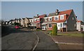
4
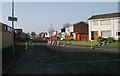
Ben More Drive
Closed for road works.
Image: © Richard Sutcliffe
Taken: 14 Feb 2017
0.07 miles
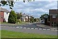
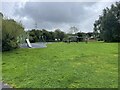
5
Open space beside Ben Lawers Drive
Image: © Richard Sutcliffe
Taken: 14 Feb 2017
0.07 miles
6
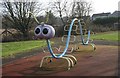
Caterpillar climbing frame
In the play park behind Ben Lawers Drive.
Image: © Richard Sutcliffe
Taken: 14 Feb 2017
0.09 miles
7
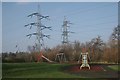
Play park and pylons
Play park behind Ben Lawers Drive.
Image: © Richard Sutcliffe
Taken: 14 Feb 2017
0.09 miles
8
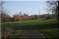
Play park behind Ben Lawers Drive
The path leads to the White Cart Water, and on to Rosshall, Pollok and into Glasgow. The tower in the far distance is part of the former Hawkhead Asylum, later known as Leverndale Hospital.
Image: © Richard Sutcliffe
Taken: 14 Feb 2017
0.09 miles
10
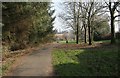
Footpath and cycle route to Rosshall
This path runs from the end of Ben Nevis Road to the White Cart Water, and on to Rosshall, Pollok and into Glasgow. The tower in the far distance is part of the former Hawkhead Asylum, later known as Leverndale Hospital (see http://www.geograph.org.uk/photo/3523078 ).
Image: © Richard Sutcliffe
Taken: 14 Feb 2017
0.10 miles