IMAGES TAKEN NEAR TO
Ben Nevis Road, PAISLEY, PA2 7LF
Introduction
This page details the photographs taken nearby to Ben Nevis Road, PA2 7LF by members of the Geograph project.
The Geograph project started in 2005 with the aim of publishing, organising and preserving representative images for every square kilometre of Great Britain, Ireland and the Isle of Man.

There are currently over 7.5m images from over14,400 individuals and you can help contribute to the project by visiting https://www.geograph.org.uk
Image Map
Images are licensed for reuse under creativecommons.org/licenses/by-sa/2.0
Notes
- Clicking on the map will re-center to the selected point.
- The higher the marker number, the further away the image location is from the centre of the postcode.
Image Listing (19 Images Found)
Images are licensed for reuse under creativecommons.org/licenses/by-sa/2.0
Image
Details
Distance
1

Postbox, Ben Lui Drive
The postbox, at the junction of Ben Lui Drive and Ben Nevis Road [http://www.geograph.org.uk/photo/5285130] is postbox number PA2 76D.
Image: © Richard Sutcliffe
Taken: 14 Feb 2017
0.02 miles
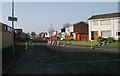
2
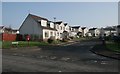
Houses on Ben Lui Drive
The postbox [http://www.geograph.org.uk/photo/5285135], at the junction of Ben Lui Drive and Ben Nevis Road, is postbox number PA2 76D.
Image: © Richard Sutcliffe
Taken: 14 Feb 2017
0.03 miles
3
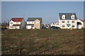
Houses on Morton Avenue
Recently built houses.
Image: © Richard Sutcliffe
Taken: 14 Feb 2017
0.05 miles
4
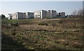
St Andrew's Academy
Seen from the east.
Image: © Richard Sutcliffe
Taken: 14 Feb 2017
0.07 miles
6
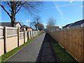
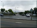
Cycle route at Hawkhead
This short section of the route leads from Morton Avenue to Ben Nevis Road. The Image, not visible in this picture, is on the other side of the wall and fence on the left.
See Image for a view in the opposite direction.
Image: © Lairich Rig
Taken: 24 Mar 2014
0.16 miles
7
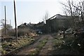
Hawkhead House Farm Steading
In a very ruinous state, and still deteriorating, despite being a Category B listed building, which dates from 1796. The area around it is full of all kinds of rubbish, old vehicles and machinery. See the Buildings at Risk Register [http://www.buildingsatrisk.org.uk/details/917323].
Image: © Richard Sutcliffe
Taken: 14 Feb 2017
0.16 miles
8
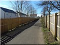
Cycle route at Hawkhead
The subject is as in Image, but viewed in the opposite direction, looking from Ben Nevis Road towards Morton Avenue.
Image: © Lairich Rig
Taken: 24 Mar 2014
0.16 miles
9
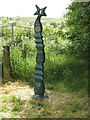
National Cycle Route 7 and 75 milepost
Recently painted.
Image: © Richard Webb
Taken: 16 Jun 2009
0.17 miles
10
Ben More Drive
Closed for road works.
Image: © Richard Sutcliffe
Taken: 14 Feb 2017
0.21 miles