IMAGES TAKEN NEAR TO
Barrhead Road, PAISLEY, PA2 7BX
Introduction
This page details the photographs taken nearby to Barrhead Road, PA2 7BX by members of the Geograph project.
The Geograph project started in 2005 with the aim of publishing, organising and preserving representative images for every square kilometre of Great Britain, Ireland and the Isle of Man.

There are currently over 7.5m images from over14,400 individuals and you can help contribute to the project by visiting https://www.geograph.org.uk
Image Map
Images are licensed for reuse under creativecommons.org/licenses/by-sa/2.0
Notes
- Clicking on the map will re-center to the selected point.
- The higher the marker number, the further away the image location is from the centre of the postcode.
Image Listing (21 Images Found)
Images are licensed for reuse under creativecommons.org/licenses/by-sa/2.0
Image
Details
Distance
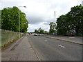
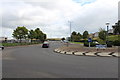
4

Roundabout on Hurlet Road (A726), Paisley
The right hand fork (B771 Grahamston Road) leads to Barrhead. The main road left leads to East Kilbride.
Image: © G Laird
Taken: 30 Apr 2014
0.12 miles
5
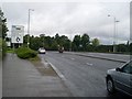
Approaching Hawkhead Roundabout
From the south, on Hurlet Road.
Image: © Stephen Sweeney
Taken: 12 Aug 2009
0.14 miles
7
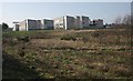
St Andrew's Academy
Seen from the east.
Image: © Richard Sutcliffe
Taken: 14 Feb 2017
0.19 miles
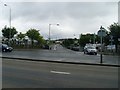
8
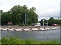
Hawkhead Roundabout
Between Hurlet Road, Barrhead Road and Hawkhead Road.
Image: © Stephen Sweeney
Taken: 12 Aug 2009
0.19 miles
9
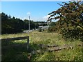
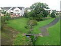
Fence on Temple Hill
The fence is on the lower southwestern slopes of the hill, and its course is marked on the 1:25000 map, which also reveals that the line of the fence corresponds to the near (i.e., the eastern) side of the course of a dismantled railway line.
A roundabout that is marked on the map can be seen in the background, through the gap: Image The fence itself is the lower edge of a plantation that is behind the photographer, and which is part of Image
Image: © Lairich Rig
Taken: 26 Aug 2019
0.19 miles
