IMAGES TAKEN NEAR TO
Strachur, CAIRNDOW, PA27 8DN
Introduction
This page details the photographs taken nearby to PA27 8DN by members of the Geograph project.
The Geograph project started in 2005 with the aim of publishing, organising and preserving representative images for every square kilometre of Great Britain, Ireland and the Isle of Man.

There are currently over 7.5m images from over14,400 individuals and you can help contribute to the project by visiting https://www.geograph.org.uk
Image Map
Images are licensed for reuse under creativecommons.org/licenses/by-sa/2.0
Notes
- Clicking on the map will re-center to the selected point.
- The higher the marker number, the further away the image location is from the centre of the postcode.
Image Listing (4 Images Found)
Images are licensed for reuse under creativecommons.org/licenses/by-sa/2.0
Image
Details
Distance
1
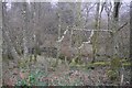
Wet woodland near Strachur
Wetland beside the A815, a nearby house is called Alderburn Cottage.
Image: © Richard Webb
Taken: 15 Dec 2018
0.10 miles
2
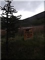
Old Milepost by the A815, Strachur
Dunoon plate by the A815, in parish of Strachur (Cowal District), South of track to Balliemeanoch, opposite white bungalow, no name.
Inscription reads:-
{pointing hand->
DUNOON
PIER
17 MILES
{diamond}
Surveyed
Milestone Society National ID: AB_DNSC17
Image: © Milestone Society
Taken: Unknown
0.10 miles
4
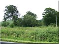
The shorter trees are hiding the Motte alongside the A815
Image: © Elliott Simpson
Taken: 11 Jul 2012
0.14 miles