IMAGES TAKEN NEAR TO
Elm Road, PAISLEY, PA2 6XP
Introduction
This page details the photographs taken nearby to Elm Road, PA2 6XP by members of the Geograph project.
The Geograph project started in 2005 with the aim of publishing, organising and preserving representative images for every square kilometre of Great Britain, Ireland and the Isle of Man.

There are currently over 7.5m images from over14,400 individuals and you can help contribute to the project by visiting https://www.geograph.org.uk
Image Map
Images are licensed for reuse under creativecommons.org/licenses/by-sa/2.0
Notes
- Clicking on the map will re-center to the selected point.
- The higher the marker number, the further away the image location is from the centre of the postcode.
Image Listing (36 Images Found)
Images are licensed for reuse under creativecommons.org/licenses/by-sa/2.0
Image
Details
Distance

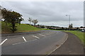
3
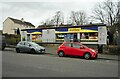
Keystore, Lochfield Road
Local convenience store.
Image: © Richard Sutcliffe
Taken: 2 Mar 2023
0.14 miles
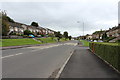
4
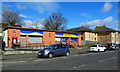
Shops in Lochfield Road
Convenience services in this busy residential area.
Image: © Mary and Angus Hogg
Taken: 4 May 2013
0.14 miles
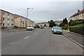
6
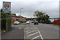
Lochfield Road
Viewed near the junction with the A726.
Image: © Mary and Angus Hogg
Taken: 4 May 2013
0.15 miles
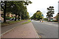
7
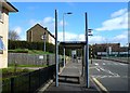
Barscube Terrace
Residential properties set back from the A726, Barrhead Road (on the right).
Image: © Richard Sutcliffe
Taken: 2 Mar 2023
0.16 miles