IMAGES TAKEN NEAR TO
Neilston Road, PAISLEY, PA2 6QD
Introduction
This page details the photographs taken nearby to Neilston Road, PA2 6QD by members of the Geograph project.
The Geograph project started in 2005 with the aim of publishing, organising and preserving representative images for every square kilometre of Great Britain, Ireland and the Isle of Man.

There are currently over 7.5m images from over14,400 individuals and you can help contribute to the project by visiting https://www.geograph.org.uk
Image Map
Images are licensed for reuse under creativecommons.org/licenses/by-sa/2.0
Notes
- Clicking on the map will re-center to the selected point.
- The higher the marker number, the further away the image location is from the centre of the postcode.
Image Listing (25 Images Found)
Images are licensed for reuse under creativecommons.org/licenses/by-sa/2.0
Image
Details
Distance
1

Disused railway line
The short-lived Paisley-Barrhead line, looking towards Barrhead from the bridge on Neilston Road, Paisley.
Image: © Thomas Nugent
Taken: 18 May 2006
0.02 miles
2
Former railway bridge on Neilston Road
Near the former Potterton station, where the former Paisley to Barrhead line passed under Neilston Road. See the other side of the parapet here Image
Image: © Thomas Nugent
Taken: 14 Jun 2013
0.04 miles
3
Former railway bridge and trackbed
Near the former Potterton station, where the former Paisley to Barrhead line passed under Neilston Road. The metal parapet is screened by the long hedge. See the road side of the parapet here Image
Image: © Thomas Nugent
Taken: 14 Jun 2013
0.04 miles
4
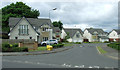
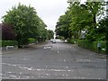
Thornly Park Avenue
The photograph was taken from the junction with Neilston Road. For another view, see Image
Image: © Lairich Rig
Taken: 28 Feb 2011
0.07 miles
5

Former railway station
Located off Neilston Road, Paisley, this was originally Potterhill station on the long since closed Paisley-Barrhead line.
Image: © Thomas Nugent
Taken: 18 May 2006
0.07 miles
6
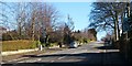
Paisley - Caplethill Road B774 (Potterhill)
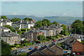
As Paisley expanded in the latter half of 19th century, the wealthier residents preferred to move away from the town centre. This development of large villas at Potterhill was then at the very southern extremity of the town.
To the extreme left Glenburn housing estate starts. Gleniffer Hotel and a garage are at this point too and local shops. This road has an excellent bus service coming from Barrhead and also Glenburn into the town centre of Paisley...
Taken: 2006:06:26 09:56:25
I also have old Postcards of this very street if that's any help to anyone.
Image: © Vic Nelson
Taken: 26 Jun 2006
0.07 miles
7
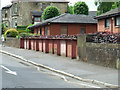
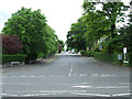
Thornly Park Avenue
In the south of Paisley.
Image: © Stephen Sweeney
Taken: 12 Aug 2009
0.08 miles
8
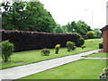
Thornly Park Avenue
Off Neilston Road.
Image: © Thomas Nugent
Taken: 14 Jun 2013
0.10 miles
9
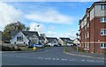
Lapsley Avenue, Paisley
Modern flats and houses in Paisley's Lapsley Avenue.
Image: © Mary and Angus Hogg
Taken: 4 May 2013
0.12 miles