IMAGES TAKEN NEAR TO
Bushes Avenue, PAISLEY, PA2 6JR
Introduction
This page details the photographs taken nearby to Bushes Avenue, PA2 6JR by members of the Geograph project.
The Geograph project started in 2005 with the aim of publishing, organising and preserving representative images for every square kilometre of Great Britain, Ireland and the Isle of Man.

There are currently over 7.5m images from over14,400 individuals and you can help contribute to the project by visiting https://www.geograph.org.uk
Image Map
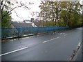
Images are licensed for reuse under creativecommons.org/licenses/by-sa/2.0
Notes
- Clicking on the map will re-center to the selected point.
- The higher the marker number, the further away the image location is from the centre of the postcode.
Image Listing (106 Images Found)
Images are licensed for reuse under creativecommons.org/licenses/by-sa/2.0
Image
Details
Distance
1
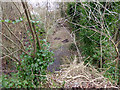
Former Potterhill Branch railway line
The disused trackbed of The Glasgow & South Western Railway Potterhill Branch line at Stanely Road. Neatly piled cut logs can be seen on the trackbed.
Image: © Thomas Nugent
Taken: 29 Feb 2016
0.06 miles
2
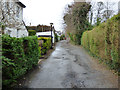
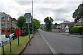
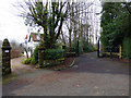
Bushes Avenue
A narrow residential lane off Park Road.
Image: © Thomas Nugent
Taken: 29 Feb 2016
0.07 miles
3
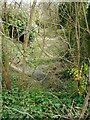
Old railway line
The route of the former Glasgow and South Western's Potterhill Branch which closed in 1970. Seen from the Stanely Road bridge.
Image: © Richard Sutcliffe
Taken: 14 Apr 2023
0.07 miles
4
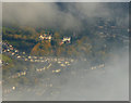
Stanely Road from the air
"Middle Park", seen through cloud shortly after take-off from Glasgow. Brodie Park is to the left, the former Brown & Polson building is just visible on the right.
Image: © Thomas Nugent
Taken: 9 Oct 2017
0.08 miles
5
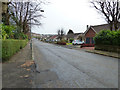
Stanley Drive, Paisley
Looking south-east from its junction with Stanley Road.
Image: © Richard Dorrell
Taken: 10 Aug 2021
0.08 miles
6
Stanely Drive
Looking down the hill towards Falside Road.
Image: © Thomas Nugent
Taken: 29 Feb 2016
0.08 miles
7
Stanely Road railway bridge
The blue railings are above the disused trackbed of The Glasgow & South Western Railway Potterhill Branch line.
Image: © Thomas Nugent
Taken: 29 Feb 2016
0.09 miles
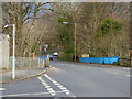
8
Bridge over old railway line
The bridge carries Stanely Road over the former Glasgow and South Western's Potterhill Branch. The line closed in 1970. On the left is the Stanely Road electricity substation.
Image: © Richard Sutcliffe
Taken: 14 Apr 2023
0.09 miles
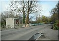
9
Road bridge over former railway line
At Stanely Road.
Image: © Stephen Sweeney
Taken: 29 Oct 2009
0.09 miles
10
Gates off Park Road
Leading to Scotscraig and Park House (on the left).
Image: © Thomas Nugent
Taken: 29 Feb 2016
0.09 miles