IMAGES TAKEN NEAR TO
CAIRNDOW, PA26 8BN
Introduction
This page details the photographs taken nearby to PA26 8BN by members of the Geograph project.
The Geograph project started in 2005 with the aim of publishing, organising and preserving representative images for every square kilometre of Great Britain, Ireland and the Isle of Man.

There are currently over 7.5m images from over14,400 individuals and you can help contribute to the project by visiting https://www.geograph.org.uk
Image Map
Images are licensed for reuse under creativecommons.org/licenses/by-sa/2.0
Notes
- Clicking on the map will re-center to the selected point.
- The higher the marker number, the further away the image location is from the centre of the postcode.
Image Listing (12 Images Found)
Images are licensed for reuse under creativecommons.org/licenses/by-sa/2.0
Image
Details
Distance
1
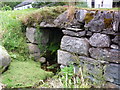
Old conduit at Cairndow
Crossing a small unnamed burn running into the loch.
Image: © sylvia duckworth
Taken: 4 Aug 2013
0.06 miles
2
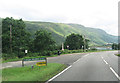
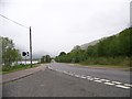
Road convergence at war memorial
Cairndow road joining A83
Image: © John Firth
Taken: 25 Jul 2012
0.08 miles
4
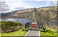
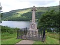
War memorial at Cairndow
The Cairndow war memorial was erected at a road junction just to the north of the village with Loch Fyne behind it.
Image: © Trevor Littlewood
Taken: 15 Apr 2023
0.09 miles
5
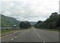
Bus stop just beyond war memorial
A83 north
Image: © John Firth
Taken: 25 Jul 2012
0.12 miles
8

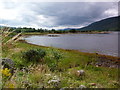
View to Cairndow
View over Loch Fyne to Cairndow.
Image: © Philip Halling
Taken: 27 Jun 2019
0.21 miles
9
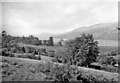
On A83 at Cairndow, westward over Loch Fyne, 1957
A beautiful scene, which I had located wrongly all these years.
Image: © Ben Brooksbank
Taken: 21 Sep 1957
0.21 miles
10
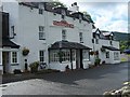
Stagecoach Inn, Cairndow
Hospitality and food great and the beer
Image: © william craig
Taken: 1 Jul 2005
0.21 miles