IMAGES TAKEN NEAR TO
CAIRNDOW, PA26 8BL
Introduction
This page details the photographs taken nearby to PA26 8BL by members of the Geograph project.
The Geograph project started in 2005 with the aim of publishing, organising and preserving representative images for every square kilometre of Great Britain, Ireland and the Isle of Man.

There are currently over 7.5m images from over14,400 individuals and you can help contribute to the project by visiting https://www.geograph.org.uk
Image Map
Images are licensed for reuse under creativecommons.org/licenses/by-sa/2.0
Notes
- Clicking on the map will re-center to the selected point.
- The higher the marker number, the further away the image location is from the centre of the postcode.
Image Listing (4 Images Found)
Images are licensed for reuse under creativecommons.org/licenses/by-sa/2.0
Image
Details
Distance
1
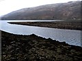
River Fyne enters the loch
The tide is well out
Image: © Alan Reid
Taken: 14 Feb 2012
0.19 miles
3
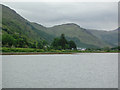
Loch Fyne Oyster Bar
The Famous Loch Fyne Oyster Bar, Smokery and Shop at Clachan at the head of Loch Fyne
Image: © phil smith
Taken: Unknown
0.23 miles
4
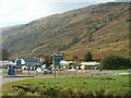
Loch Fyne Oyster Bar
The Loch Fyne Oyster Bar has grown from humble beginnings to become one of the largest producers of shellfish and smoked fish products in the area. The site is also home to the Ardkinglass Estate's tree shop and the Cairndow community project.
Image: © Patrick Mackie
Taken: 16 Oct 2006
0.23 miles