IMAGES TAKEN NEAR TO
St. Catherines, CAIRNDOW, PA25 8BA
Introduction
This page details the photographs taken nearby to PA25 8BA by members of the Geograph project.
The Geograph project started in 2005 with the aim of publishing, organising and preserving representative images for every square kilometre of Great Britain, Ireland and the Isle of Man.

There are currently over 7.5m images from over14,400 individuals and you can help contribute to the project by visiting https://www.geograph.org.uk
Image Map
Images are licensed for reuse under creativecommons.org/licenses/by-sa/2.0
Notes
- Clicking on the map will re-center to the selected point.
- The higher the marker number, the further away the image location is from the centre of the postcode.
Image Listing (12 Images Found)
Images are licensed for reuse under creativecommons.org/licenses/by-sa/2.0
Image
Details
Distance
1
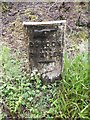
Old Milepost by the A815 at Ardnagowan
Dunoon plate by the A815, in parish of Strachur (Cowal District), Ardnagowan, on verge in woods, East side of road.
Inscription reads:-
{Hand>}
DUNOON
PIER
21 MILES
Surveyed
Milestone Society National ID: AB_DNSC21
Image: © Milestone Society
Taken: Unknown
0.03 miles
2
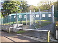
Ministry of Defence building St Catherines Loch Fyne
Image: © John Ferguson
Taken: 30 Oct 2010
0.05 miles
3
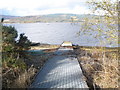
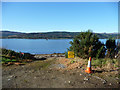
Ministry of Defence slipway Loch Fyne
Image: © John Ferguson
Taken: 30 Oct 2010
0.07 miles
4
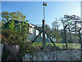
Control building at Loch Fyne Noise Range
The noise range is used to assess the noise signatures of Navy vessels. The range is maintained by defence contractor Qinetiq. This compound is beside the old road running along the shore of the loch. http://www.secretscotland.org.uk/index.php/Secrets/LochFyneNoiseRange
Image: © Phil Champion
Taken: 16 Oct 2009
0.07 miles
5
Slip at Loch Fyne Noise Range
The Loch Fyne Noise Range is used to assess the noise signatures of Navy vessels and is maintained by defence contractor QinetiQ. The range pontoon can be seen out on the loch. http://www.secretscotland.org.uk/index.php/Secrets/LochFyneNoiseRange
Image: © Phil Champion
Taken: 16 Oct 2009
0.07 miles
6
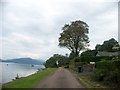
Strachur to St. Catherines old Road at Ardnagowan
Image: © Elliott Simpson
Taken: 2 Aug 2011
0.10 miles
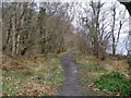
7
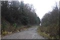
Forest road, Ardnagowan
The track climbs high above Loch Fyne.
Image: © Richard Webb
Taken: 15 Dec 2018
0.12 miles
8
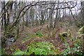
Woodland beside Loch Fyne
Between the A815 and Loch Fyne.
Image: © Richard Webb
Taken: 15 Dec 2018
0.19 miles
10
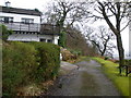
Holiday cottage
On the old road between Strachur and St Catherines
Image: © John Ferguson
Taken: 14 Mar 2009
0.22 miles