IMAGES TAKEN NEAR TO
Lochgoilhead, CAIRNDOW, PA24 8AN
Introduction
This page details the photographs taken nearby to PA24 8AN by members of the Geograph project.
The Geograph project started in 2005 with the aim of publishing, organising and preserving representative images for every square kilometre of Great Britain, Ireland and the Isle of Man.

There are currently over 7.5m images from over14,400 individuals and you can help contribute to the project by visiting https://www.geograph.org.uk
Image Map (Loading...)


Getting Data...Please wait
Leaflet Map data © OpenStreetMap
Images are licensed for reuse under creativecommons.org/licenses/by-sa/2.0
Notes
- Clicking on the map will re-center to the selected point.
- The higher the marker number, the further away the image location is from the centre of the postcode.
Image Listing (8 Images Found)
Images are licensed for reuse under creativecommons.org/licenses/by-sa/2.0
Image
Details
Distance
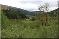
4
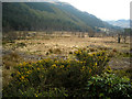
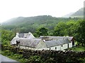
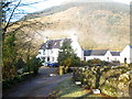
Glen Goil
Drumsyniebeag House at the foot of Muttach Coire a'Chuir.
Image: © wfmillar
Taken: 14 Apr 2008
0.15 miles
5
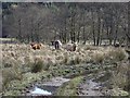
Cattle beside the River Goil
Alders mark the course of the river. Shorthorn bull flanked by two more familiar cattle. I don't think I have ever seen a Beef Shorthorn bull outside a showground before.
Image: © Richard Webb
Taken: 9 Apr 2006
0.17 miles
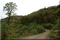
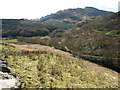
6
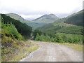
Forestry Road above Glen Goil
Beinn an Lochain in the background
Image: © John Ferguson
Taken: 5 Jul 2010
0.20 miles