IMAGES TAKEN NEAR TO
Lochgoilhead, CAIRNDOW, PA24 8AE
Introduction
This page details the photographs taken nearby to PA24 8AE by members of the Geograph project.
The Geograph project started in 2005 with the aim of publishing, organising and preserving representative images for every square kilometre of Great Britain, Ireland and the Isle of Man.

There are currently over 7.5m images from over14,400 individuals and you can help contribute to the project by visiting https://www.geograph.org.uk
Image Map
Images are licensed for reuse under creativecommons.org/licenses/by-sa/2.0
Notes
- Clicking on the map will re-center to the selected point.
- The higher the marker number, the further away the image location is from the centre of the postcode.
Image Listing (5 Images Found)
Images are licensed for reuse under creativecommons.org/licenses/by-sa/2.0
Image
Details
Distance
1
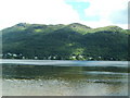
View from beach at Ardroy
Taken while on outdoor education trip with school
Image: © tony ferrie
Taken: 13 Jun 2005
0.12 miles
3
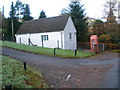
Telephone Exchange on the road to Carrick
Image: © John Ferguson
Taken: 8 Nov 2009
0.19 miles
4
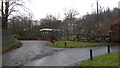
Substation above Douglas Pier
Douglas Pier, over the road on the left is a War Office research station for marine noise suppression and detection and torpedo design. I presume the torpedo work moved over from Loch Long.
Image: © Richard Webb
Taken: 7 Jan 2012
0.21 miles