IMAGES TAKEN NEAR TO
Blairmore, DUNOON, PA23 8TL
Introduction
This page details the photographs taken nearby to PA23 8TL by members of the Geograph project.
The Geograph project started in 2005 with the aim of publishing, organising and preserving representative images for every square kilometre of Great Britain, Ireland and the Isle of Man.

There are currently over 7.5m images from over14,400 individuals and you can help contribute to the project by visiting https://www.geograph.org.uk
Image Map (Loading...)


Getting Data...Please wait
Leaflet Map data © OpenStreetMap
Images are licensed for reuse under creativecommons.org/licenses/by-sa/2.0
Notes
- Clicking on the map will re-center to the selected point.
- The higher the marker number, the further away the image location is from the centre of the postcode.
Image Listing (20 Images Found)
Images are licensed for reuse under creativecommons.org/licenses/by-sa/2.0
Image
Details
Distance
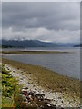
1
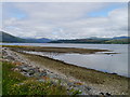
Low Tide, Loch Long-side
A view up Loch Long from the north end of Blairmore; the clear day permits a view as far as the 'Arrochar Alps'.
Image: © James T M Towill
Taken: 11 Aug 2015
0.03 miles
2
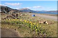
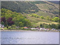
Spring comes to the North end of Blairmore
Image: © Alan Reid
Taken: 5 Apr 2013
0.05 miles
3
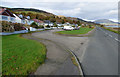
Shore Road, Blairmore
It looks like the road has been realigned away from the houses at some point in the past.
Image: © Thomas Nugent
Taken: 5 Nov 2019
0.05 miles
5
Blairmore - the "low-tide beach"
Taken from the Waverley Paddle Steamer. The group of houses near and in the "crescent" road across from the large stony beach which appears at low tide.
Image: © Annie Feeley
Taken: 20 May 2004
0.06 miles
6

Houses on Shore Road
The houses are on an old alignment of Shore Road, the new road is just out of sight on the right. Blairmore Hill is in the distance.
Image: © Thomas Nugent
Taken: 8 Nov 2019
0.06 miles
7
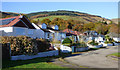
Houses on Shore Road
The houses are on an old alignment of Shore Road, the new road is just out of sight on the right. Blairmore Hill is in the distance.
Image: © Thomas Nugent
Taken: 8 Nov 2019
0.06 miles
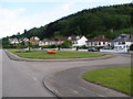
8
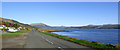
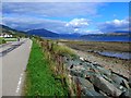
The A880 Shore Road
This is the northern extent of the road which becomes a minor road just beyond the row of houses.
Image: © Thomas Nugent
Taken: 8 Nov 2019
0.06 miles
9
A View Up Loch Long
A view up Loch Long towards Gairletter and beyond, Ardentinny.
Image: © James T M Towill
Taken: 8 Sep 2012
0.08 miles
10
Leaving Blairmore
Where the colour of the tarmac changes is where the A880 ends and the single-track 'yellow road' starts.
Looking up Loch Long towards the mountain range known as "The Arrochar Alps".
Image: © Gordon Brown
Taken: 20 Sep 2016
0.10 miles