IMAGES TAKEN NEAR TO
Loch Eck, DUNOON, PA23 8SG
Introduction
This page details the photographs taken nearby to PA23 8SG by members of the Geograph project.
The Geograph project started in 2005 with the aim of publishing, organising and preserving representative images for every square kilometre of Great Britain, Ireland and the Isle of Man.

There are currently over 7.5m images from over14,400 individuals and you can help contribute to the project by visiting https://www.geograph.org.uk
Image Map
Images are licensed for reuse under creativecommons.org/licenses/by-sa/2.0
Notes
- Clicking on the map will re-center to the selected point.
- The higher the marker number, the further away the image location is from the centre of the postcode.
Image Listing (11 Images Found)
Images are licensed for reuse under creativecommons.org/licenses/by-sa/2.0
Image
Details
Distance
1
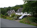
Cottages at Allt na Blathaich Loch Eck
Image: © John Ferguson
Taken: 23 Jul 2009
0.01 miles
3
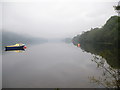
Misty Loch Eck shoreline at Allt na Blathaich
Image: © John Ferguson
Taken: 9 Sep 2010
0.06 miles
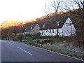
4
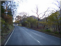
The A815 road at Loch Eck
Heading south, just north of Allt na Blathaich.
Image: © Thomas Nugent
Taken: 8 Nov 2019
0.07 miles
5
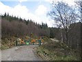
Logging road, Allt na Blathaich
Forestry Commission road rising from the shores of Loch Eck.
Image: © Richard Webb
Taken: 27 Apr 2008
0.10 miles
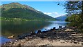
8
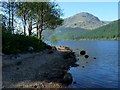
The shore of Loch Eck opposite Rubha Ban Frionais
Image: © Alan Reid
Taken: 27 May 2012
0.19 miles
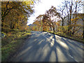
9
The A815 road at Loch Eck
Heading south, just south of Allt na Blathaich.
Image: © Thomas Nugent
Taken: 8 Nov 2019
0.19 miles
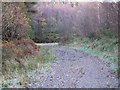
10
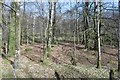
Woodland beside Loch Eck
On the east bank. The conifers resume not too far in.
Image: © Richard Webb
Taken: 26 Mar 2017
0.22 miles