IMAGES TAKEN NEAR TO
Ferrymans, DUNOON, PA23 8RW
Introduction
This page details the photographs taken nearby to Ferrymans, PA23 8RW by members of the Geograph project.
The Geograph project started in 2005 with the aim of publishing, organising and preserving representative images for every square kilometre of Great Britain, Ireland and the Isle of Man.

There are currently over 7.5m images from over14,400 individuals and you can help contribute to the project by visiting https://www.geograph.org.uk
Image Map (Loading...)


Getting Data...Please wait
Leaflet Map data © OpenStreetMap
Images are licensed for reuse under creativecommons.org/licenses/by-sa/2.0
Notes
- Clicking on the map will re-center to the selected point.
- The higher the marker number, the further away the image location is from the centre of the postcode.
Image Listing (51 Images Found)
Images are licensed for reuse under creativecommons.org/licenses/by-sa/2.0
Image
Details
Distance
1
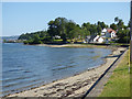
The Holy Loch at Lazaretto Point
The east side of the point, looking towards Hunters Quay.
Image: © Thomas Nugent
Taken: 2 Jul 2018
0.06 miles
2
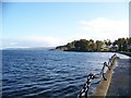
Looking down the Holy Loch from Lazaretto Point
Lazaretto Point takes its name from the quarantine station and storage houses that were built in 1807, during the Napoleonic Wars. Lazar House, or Lazaretto, was the name for a hospital, first established by the Order of St. Lazarus. People suffering from leprosy, the plague and other infectious and contagious diseases were taken care of at this site. The Ships from foreign ports would ride out the period of quarantine, while their cargo would be discharged on to the station. See http://www.sandbank-dt.org.uk/index.php?option=com_content&task=view&id=5&Itemid=6
There is also a Lazaretto Point at the harbour in Baltimore which also acquired its name from a quarantine hospital. See http://en.wikipedia.org/wiki/Lazaretto_Point_Light
Image: © Elliott Simpson
Taken: 18 Oct 2008
0.06 miles
3
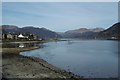
Holy Loch
View along the shore towards the monument at Lazaretto Point.
Image: © Richard Webb
Taken: 26 Mar 2017
0.07 miles
4
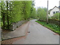
Ferry Road, Ardnadam
Looking south-westward.
Image: © Peter Wood
Taken: 4 May 2024
0.07 miles
5
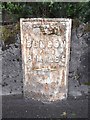
Old Milepost by the A815, Ardnadam, Dunoon and Kilmun parish
Dunoon plate by the A815, in parish of Dunoon and Kilmun (Argyll and Bute District), by Glen Cottage, Ardnadam, built into wall, Southwest side of road.
Inscription reads:-
{<-hand}
DUNOON
PIER
3 MILES
{diamond}
Surveyed
Milestone Society National ID: AB_DNSR03
Image: © Milestone Society
Taken: Unknown
0.08 miles
6
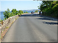
The A815 road
Approaching Hafton House from Lazaretto Point.
Image: © Thomas Nugent
Taken: 2 Jul 2018
0.09 miles
7
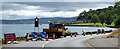
Temporary traffic lights
On the A815 Shore Road between Ardnadam and Hunters Quay.
Image: © Thomas Nugent
Taken: 1 Jul 2019
0.10 miles
8
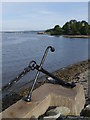
An Anchor At Lazaretto Point
A hard landscaped area at Ardnadam.
Image: © James T M Towill
Taken: 25 Jul 2012
0.11 miles
9
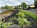
Shore Road at Ardnadam
Looking south towards Hunter's Quay. The yellow plant is Sea Radish Image
Image: © M J Richardson
Taken: 30 May 2017
0.12 miles
