IMAGES TAKEN NEAR TO
Hafton, DUNOON, PA23 8HP
Introduction
This page details the photographs taken nearby to Hafton, PA23 8HP by members of the Geograph project.
The Geograph project started in 2005 with the aim of publishing, organising and preserving representative images for every square kilometre of Great Britain, Ireland and the Isle of Man.

There are currently over 7.5m images from over14,400 individuals and you can help contribute to the project by visiting https://www.geograph.org.uk
Image Map (Loading...)


Getting Data...Please wait
Leaflet Map data © OpenStreetMap
Images are licensed for reuse under creativecommons.org/licenses/by-sa/2.0
Notes
- Clicking on the map will re-center to the selected point.
- The higher the marker number, the further away the image location is from the centre of the postcode.
Image Listing (20 Images Found)
Images are licensed for reuse under creativecommons.org/licenses/by-sa/2.0
Image
Details
Distance

2
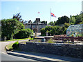
Hafton House
By the A815 Shore Road.
Web site: http://www.hafton-castle.co.uk/ .
Image: © Thomas Nugent
Taken: 2 Jul 2018
0.14 miles
3
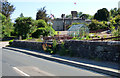
Hafton House
By the A815 Shore Road.
Web site: http://www.hafton-castle.co.uk/ .
Image: © Thomas Nugent
Taken: 2 Jul 2018
0.14 miles
4

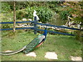
Grounds of Hafton
Looking across Holy Loch to Strone
Image: © John Ferguson
Taken: 19 Mar 2009
0.16 miles
5
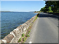
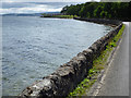
The A815 Shore Road
Running along the south bank of the Holy Loch at Hafton House.
Image: © Thomas Nugent
Taken: 2 Jul 2018
0.17 miles

8
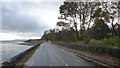
Shore Road
The A815 on the south bank of the Holy Loch, approaching Hunters Quay.
Image: © Thomas Nugent
Taken: 1 Jul 2019
0.17 miles
10
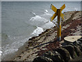
Outfall marker, Holy Loch
The yellow X is used as standard to mark the location of an outfall, normally waste water. This one is by the A815 Shore Road on the south side of the loch.
Image: © Thomas Nugent
Taken: 1 Jul 2019
0.20 miles