IMAGES TAKEN NEAR TO
Ferry Lane, DUNOON, PA23 7TQ
Introduction
This page details the photographs taken nearby to Ferry Lane, PA23 7TQ by members of the Geograph project.
The Geograph project started in 2005 with the aim of publishing, organising and preserving representative images for every square kilometre of Great Britain, Ireland and the Isle of Man.

There are currently over 7.5m images from over14,400 individuals and you can help contribute to the project by visiting https://www.geograph.org.uk
Image Map (Loading...)


Getting Data...Please wait
Leaflet Map data © OpenStreetMap
Images are licensed for reuse under creativecommons.org/licenses/by-sa/2.0
Notes
- Clicking on the map will re-center to the selected point.
- The higher the marker number, the further away the image location is from the centre of the postcode.
Image Listing (26 Images Found)
Images are licensed for reuse under creativecommons.org/licenses/by-sa/2.0
Image
Details
Distance
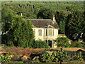
3
Derelict house at Ferry Bay
One wonders what the story behind this house is? It is just visible through trees on Google Earth imagery from 2009, and looks lived-in, with the lawn recently cut. Since then it has been boarded-up and most of the trees cut down, the windows boarded up, and a once-upon-a-time elegant conservatory in decay. It has deteriorated considerably since IanS was there in 2013 - Image
Update:- June 2020. The house has gone, as have most of the trees on the site, and replaced with a self-build house [Thanks to Jonathan Miles for this information].
Image: © M J Richardson
Taken: 29 May 2017
0.05 miles
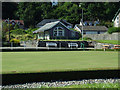
5
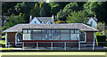
Innellan Bowling and Tennis Club
The bowling clubhouse.
Image: © Thomas Nugent
Taken: 10 Aug 2012
0.07 miles
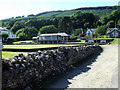
6
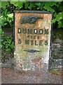
Old Milepost by the A815, Shore Road, Innellan
Dunoon plate by the A815, in parish of Dunoon and Kilmun (Argyll & Bute District), Shore Road, Innellan, near wall on bend, West side of road.
Inscription reads:-
{hand->}
DUNOON
PIER
5 MILES
{diamond}
Surveyed
Milestone Society National ID: AB_DNTO05
Image: © Milestone Society
Taken: Unknown
0.07 miles
7
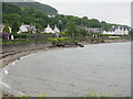
Ferry Bay, Innellan
Looking north from near Ferry Rocks
Image: © M J Richardson
Taken: 29 May 2017
0.08 miles
8
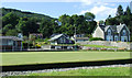
Innellan Bowling and Tennis Club
Bowling in the foreground, tennis in the background.
Image: © Thomas Nugent
Taken: 10 Aug 2012
0.09 miles
9
Innellan Bowling and Tennis Club
The tennis clubhouse is in the background.
Image: © Thomas Nugent
Taken: 10 Aug 2012
0.09 miles
10
Innellan Bowling and Tennis Club
On the coast road in Innellan.
Image: © Thomas Nugent
Taken: 10 Aug 2012
0.10 miles