IMAGES TAKEN NEAR TO
Shore Road, DUNOON, PA23 7TN
Introduction
This page details the photographs taken nearby to Shore Road, PA23 7TN by members of the Geograph project.
The Geograph project started in 2005 with the aim of publishing, organising and preserving representative images for every square kilometre of Great Britain, Ireland and the Isle of Man.

There are currently over 7.5m images from over14,400 individuals and you can help contribute to the project by visiting https://www.geograph.org.uk
Image Map
Images are licensed for reuse under creativecommons.org/licenses/by-sa/2.0
Notes
- Clicking on the map will re-center to the selected point.
- The higher the marker number, the further away the image location is from the centre of the postcode.
Image Listing (18 Images Found)
Images are licensed for reuse under creativecommons.org/licenses/by-sa/2.0
Image
Details
Distance

3
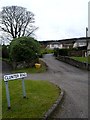
Cluniter Road
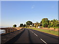
All the roads leading inland climb steeply from Shore Road in Innellan
Image: © Alan Reid
Taken: 12 Feb 2012
0.06 miles
4
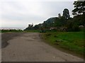
Scruffy picnic spot off Shore Road, Cluniter
Image: © Gordon Brown
Taken: 15 Sep 2016
0.07 miles
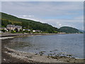
5
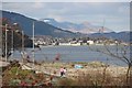
Walkers pass the shingle point at Cluniter
Dunoon and the Arrochar Alps (Beinn Narnain) complete the scene.
Image: © Alan Reid
Taken: 27 Apr 2013
0.07 miles
6
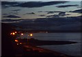
A new day dawns at Innellan
First light in the eastern sky on the Firth of Clyde
Image: © Alan Reid
Taken: 18 Sep 2011
0.09 miles
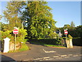
7

Grand house by Burnmakiman Burn, Innellan
Image: © Alan Reid
Taken: 31 Dec 2018
0.09 miles
8
Coastline At Cluniter
A view of the coastline near Innellan.
Image: © James T M Towill
Taken: 4 Aug 2012
0.11 miles
10
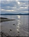
Dawn on the Clyde at Cluniter
A small alluvial fan where the Burnmakiman Burn reaches the Firth of Clyde.
Image: © Alan Reid
Taken: 11 Jul 2017
0.11 miles