IMAGES TAKEN NEAR TO
Argyll Street, DUNOON, PA23 7RN
Introduction
This page details the photographs taken nearby to Argyll Street, PA23 7RN by members of the Geograph project.
The Geograph project started in 2005 with the aim of publishing, organising and preserving representative images for every square kilometre of Great Britain, Ireland and the Isle of Man.

There are currently over 7.5m images from over14,400 individuals and you can help contribute to the project by visiting https://www.geograph.org.uk
Image Map
Images are licensed for reuse under creativecommons.org/licenses/by-sa/2.0
Notes
- Clicking on the map will re-center to the selected point.
- The higher the marker number, the further away the image location is from the centre of the postcode.
Image Listing (45 Images Found)
Images are licensed for reuse under creativecommons.org/licenses/by-sa/2.0
Image
Details
Distance
1
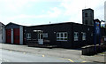
Dunoon Community Fire Station
On Argyll Street.
Image: © Thomas Nugent
Taken: 10 Aug 2012
0.01 miles
2
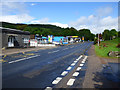
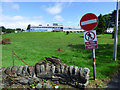
Argyll Street
The A885 heading out of Dunoon towards Sandbank.
Image: © Thomas Nugent
Taken: 1 Jul 2019
0.01 miles
4
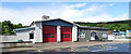
Dunoon fire station
Scottish Fire and Rescue Service station on Argyll Street on the outskirts of the town.
Image: © Thomas Nugent
Taken: 1 Jul 2019
0.03 miles
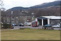
5
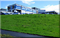
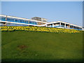
Cowal Community Hospital
Viewed from Argyll Street.
Image: © Thomas Nugent
Taken: 1 Jul 2019
0.05 miles
6
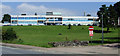
Cowal Community Hospital
The vehicle exit onto Argyll Street.
Image: © Thomas Nugent
Taken: 1 Jul 2019
0.05 miles
9
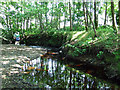
Milton Burn
Looking upstream near Dunoon Cemetery.
Image: © Thomas Nugent
Taken: 10 Aug 2012
0.06 miles
10
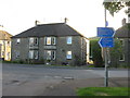
Houses, Argyll Street, Dunoon
And foot- and cycle-path sign.
Image: © M J Richardson
Taken: 30 May 2017
0.07 miles