IMAGES TAKEN NEAR TO
Kirk Street, DUNOON, PA23 7DP
Introduction
This page details the photographs taken nearby to Kirk Street, PA23 7DP by members of the Geograph project.
The Geograph project started in 2005 with the aim of publishing, organising and preserving representative images for every square kilometre of Great Britain, Ireland and the Isle of Man.

There are currently over 7.5m images from over14,400 individuals and you can help contribute to the project by visiting https://www.geograph.org.uk
Image Map
Images are licensed for reuse under creativecommons.org/licenses/by-sa/2.0
Notes
- Clicking on the map will re-center to the selected point.
- The higher the marker number, the further away the image location is from the centre of the postcode.
Image Listing (283 Images Found)
Images are licensed for reuse under creativecommons.org/licenses/by-sa/2.0
Image
Details
Distance
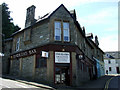
1
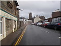
Kirk Street - viewed from Ferry Brae
Image: © Betty Longbottom
Taken: 26 Sep 2019
0.01 miles
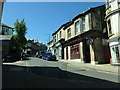
2
Ferry Brae
Looking up the hill from Argyll Street.
Image: © Thomas Nugent
Taken: 10 Aug 2012
0.01 miles
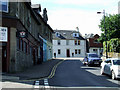
5
Ingrams Bar
At the corner of Ferry Brae and School Brae.
Image: © Thomas Nugent
Taken: 10 Aug 2012
0.03 miles

7
Ferry Brae, Dunoon
Climbing up from an 11 metre spot height at the junction with Argyll Street.
Image: © Christine Johnstone
Taken: 27 Jun 2019
0.04 miles
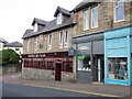
9
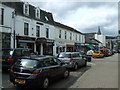
Argyll Street
The main shopping street in Dunoon.
Image: © Thomas Nugent
Taken: 3 Jun 2008
0.05 miles
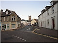
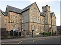
10
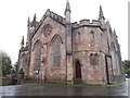
High Kirk (Church of Scotland) - viewed from Kirk Street
Image: © Betty Longbottom
Taken: 26 Sep 2019
0.05 miles