IMAGES TAKEN NEAR TO
Springvale Drive, PAISLEY, PA2 0PH
Introduction
This page details the photographs taken nearby to Springvale Drive, PA2 0PH by members of the Geograph project.
The Geograph project started in 2005 with the aim of publishing, organising and preserving representative images for every square kilometre of Great Britain, Ireland and the Isle of Man.

There are currently over 7.5m images from over14,400 individuals and you can help contribute to the project by visiting https://www.geograph.org.uk
Image Map
Images are licensed for reuse under creativecommons.org/licenses/by-sa/2.0
Notes
- Clicking on the map will re-center to the selected point.
- The higher the marker number, the further away the image location is from the centre of the postcode.
Image Listing (16 Images Found)
Images are licensed for reuse under creativecommons.org/licenses/by-sa/2.0
Image
Details
Distance
1
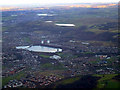
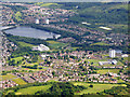
SouthPaisley from the air
Elderslie golf course is in the foreground. Stanely reservoir and castle are prominent in the centre, with Glenburn and Harelaw reservoirs on the hill beyond. Barrhead and Balgray reservoir are in the distance, with a sliver of Waulkmill Glen reservoir visible to the top left.
Image: © Thomas Nugent
Taken: 7 Feb 2011
0.11 miles
2
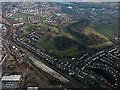
Elderslie Golf Club from the air
WH Malcolm's railway yard is in the foreground, Stanely reservoir and castle are in the distance.
Image: © Thomas Nugent
Taken: 18 Mar 2015
0.11 miles
3
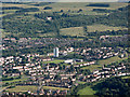
Foxbar from the air
The towerblock is Oliphant Court.
Image: © Thomas Nugent
Taken: 19 Jul 2015
0.11 miles
4
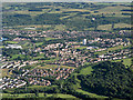
Foxbar from the air
Elderslie Golf Club is also visible.
Image: © Thomas Nugent
Taken: 19 Jul 2015
0.11 miles
5
Foxbar and Stanely Reservoir from the air
St paul's RC Church can be seen in the lower right corner Image
Image: © Thomas Nugent
Taken: 5 Jun 2017
0.11 miles
6
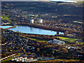
Foxbar and Stanely Reservoir from the air
Stanely Castle can be seen in the water on the right side of the larger reservoir.
Image: © Thomas Nugent
Taken: 3 Dec 2018
0.11 miles
7
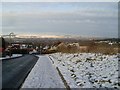
View from Dee Drive, Foxbar
Fine view north across Millarston and Ferguslie Park, over to the Kilpatrick Hills in West Dunbartonshire over in the distance.
Image: © Stephen Sweeney
Taken: 3 Jan 2010
0.15 miles
8
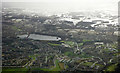
Foxbar and Stanely Reservoir from the air
Snow on the Gleniffer Braes at the tail end of Storm Ciara.
Image: © Thomas Nugent
Taken: 10 Feb 2020
0.15 miles
9
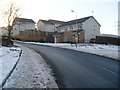
Entering Foxbar
From Fulbar Road into Dee Drive.
Image: © Stephen Sweeney
Taken: 3 Jan 2010
0.16 miles
10
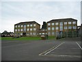
St Paul's Primary School, Foxbar
A relatively successful primary school with around 200 pupils.
Image: © John Allan
Taken: 2 Aug 2006
0.18 miles