IMAGES TAKEN NEAR TO
Locksley Road, PAISLEY, PA2 0PE
Introduction
This page details the photographs taken nearby to Locksley Road, PA2 0PE by members of the Geograph project.
The Geograph project started in 2005 with the aim of publishing, organising and preserving representative images for every square kilometre of Great Britain, Ireland and the Isle of Man.

There are currently over 7.5m images from over14,400 individuals and you can help contribute to the project by visiting https://www.geograph.org.uk
Image Map
Images are licensed for reuse under creativecommons.org/licenses/by-sa/2.0
Notes
- Clicking on the map will re-center to the selected point.
- The higher the marker number, the further away the image location is from the centre of the postcode.
Image Listing (26 Images Found)
Images are licensed for reuse under creativecommons.org/licenses/by-sa/2.0
Image
Details
Distance
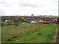
1
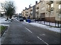
Brediland Road, Foxbar
Residential area in the southwest of Paisley.
Image: © Stephen Sweeney
Taken: 3 Jan 2010
0.04 miles
2
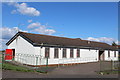
Foxbar Rivers Community Centre, Paisley
Image: © Leslie Barrie
Taken: 9 Jul 2014
0.05 miles
3
Spey Avenue from Findhorn Avenue
In Foxbar, Paisley.
Image: © Stephen Sweeney
Taken: 3 Jan 2010
0.06 miles
4
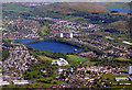
Stanely Reservoir from the air
Stanely Castle can be seen in the water on the right side of the reservoir.
Image: © Thomas Nugent
Taken: 14 May 2018
0.10 miles
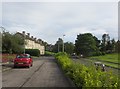
5
Brediland Road, Foxbar
Autumnal view from Amochrie Way.
Image: © wfmillar
Taken: 20 Oct 2010
0.11 miles
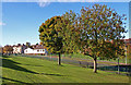
6
Foxbar from Dee Drive
View of the Foxbar area to the South of Paisley. The grass area in the foreground has been cleared of Council housing. Paisley South Housing Association has developed new housing in the area a sample of which is to the right of the picture.
Image: © Gordon Dowie
Taken: 30 Apr 2010
0.11 miles
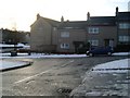
7
Brediland Road, Foxbar
Outside St Paul's Church.
Image: © Richard Webb
Taken: 1 Sep 2015
0.13 miles
8
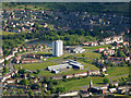
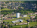
Foxbar from the air
St Paul's RC Church on Brediland Road is in the foreground. Heriot Primary School is in the centre, with Oliphant Court towerblock and Durrockstock Dam just beyond.
Image: © Thomas Nugent
Taken: 15 May 2016
0.13 miles
9
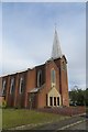
St Paul's Church, Foxbar
Catholic church on Brediland Road.
Image: © Richard Webb
Taken: 1 Sep 2015
0.14 miles
10
Foxbar from the air
The tower of St Paul's RC Church on Brediland Road is in the foreground. Heriot Primary School is in the centre, with Oliphant Court towerblock and Durrockstock Dam just beyond. Foxbar Road and Hollows Avenue are in the background.
Image: © Thomas Nugent
Taken: 15 May 2016
0.16 miles