IMAGES TAKEN NEAR TO
Montrose Road, PAISLEY, PA2 0LX
Introduction
This page details the photographs taken nearby to Montrose Road, PA2 0LX by members of the Geograph project.
The Geograph project started in 2005 with the aim of publishing, organising and preserving representative images for every square kilometre of Great Britain, Ireland and the Isle of Man.

There are currently over 7.5m images from over14,400 individuals and you can help contribute to the project by visiting https://www.geograph.org.uk
Image Map
Images are licensed for reuse under creativecommons.org/licenses/by-sa/2.0
Notes
- Clicking on the map will re-center to the selected point.
- The higher the marker number, the further away the image location is from the centre of the postcode.
Image Listing (5 Images Found)
Images are licensed for reuse under creativecommons.org/licenses/by-sa/2.0
Image
Details
Distance
1
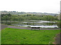
Durrockstock Dam, Foxbar, Paisley
Pond in Durrockstock Park just to the east of Waverley Road.
Image: © G Laird
Taken: 28 Apr 2014
0.11 miles
2
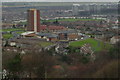
Foxbar High Flats
This area was Foxbar high flats up till 11.2004. After the date of demolition these rest homes for the elderly were built.
Image: © Vic Nelson
Taken: 27 Jan 2007
0.14 miles
3
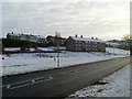
Houses in Foxbar
Jarvie Way from Brediland Road.
Image: © Stephen Sweeney
Taken: 3 Jan 2010
0.20 miles
4
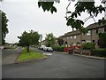
Foxbar Road
A main road in the Foxbar estate, one of the Glasgow overspill developments of the 1960s.
Image: © John Allan
Taken: 2 Aug 2006
0.23 miles
5
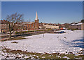
Brediland Road, Foxbar, Paisley
St.Paul's Church viewed from Mannering Road.
Image: © wfmillar
Taken: 2 Mar 2010
0.25 miles