IMAGES TAKEN NEAR TO
High Street, ISLE OF BUTE, PA20 9AU
Introduction
This page details the photographs taken nearby to High Street, PA20 9AU by members of the Geograph project.
The Geograph project started in 2005 with the aim of publishing, organising and preserving representative images for every square kilometre of Great Britain, Ireland and the Isle of Man.

There are currently over 7.5m images from over14,400 individuals and you can help contribute to the project by visiting https://www.geograph.org.uk
Image Map
Images are licensed for reuse under creativecommons.org/licenses/by-sa/2.0
Notes
- Clicking on the map will re-center to the selected point.
- The higher the marker number, the further away the image location is from the centre of the postcode.
Image Listing (463 Images Found)
Images are licensed for reuse under creativecommons.org/licenses/by-sa/2.0
Image
Details
Distance
2
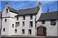
Bute Estate Office, High Street, Rothesay
Category A-listed, dating from the 17th century and once the town house of the Marquess of Bute.
Image: © Leslie Barrie
Taken: 8 Jul 2013
0.01 miles
3
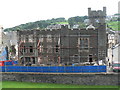
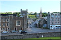
Rothesay: large building undergoing work
Substantial work is being carried out on this imposing façade.
Image: © Chris Downer
Taken: 28 Jul 2008
0.01 miles
4
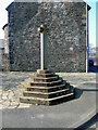
Rothesay Market Cross
A 20th Century reproduction of an earlier cross that stood at nearby Castle Street. Category C Listed http://portal.historicenvironment.scot/designation/LB40458 .
Image: © Thomas Nugent
Taken: 23 Mar 2022
0.02 miles
5
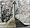
Rothesay Market Cross - Isle of Bute
This 20th century market cross that stands at the junction of High Street and Stuart Street, replaces the medieval cross that originally stood at the junction between the High Street and Castle Street.
Image: © Raibeart MacAoidh
Taken: 19 Mar 2018
0.02 miles
6
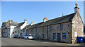
High Street, Rothesay
The white building is the former Bute Estate office, originally the Marquess of Bute's town house and later a Custom's House. Category A Listed http://portal.historicenvironment.scot/designation/LB40456 . The nearer buildings are Category B Listed http://portal.historicenvironment.scot/designation/LB40457 .
Image: © Thomas Nugent
Taken: 23 Mar 2022
0.02 miles

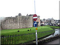
10
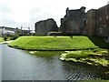
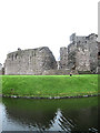
Bute - Rothesay - Castle - Eastern section of moat
Looking along the eastern section of the moat around Rothesay Castle with Stuart Street straight ahead. The prominent building is 3 Stuart Street which dates from the early C19th and is Category 'B' listed http://portal.historicenvironment.scot/designation/LB40459
Image: © Rob Farrow
Taken: 26 Jun 2022
0.03 miles