IMAGES TAKEN NEAR TO
Duncan Street, ISLE OF BUTE, PA20 0LY
Introduction
This page details the photographs taken nearby to Duncan Street, PA20 0LY by members of the Geograph project.
The Geograph project started in 2005 with the aim of publishing, organising and preserving representative images for every square kilometre of Great Britain, Ireland and the Isle of Man.

There are currently over 7.5m images from over14,400 individuals and you can help contribute to the project by visiting https://www.geograph.org.uk
Image Map
Images are licensed for reuse under creativecommons.org/licenses/by-sa/2.0
Notes
- Clicking on the map will re-center to the selected point.
- The higher the marker number, the further away the image location is from the centre of the postcode.
Image Listing (167 Images Found)
Images are licensed for reuse under creativecommons.org/licenses/by-sa/2.0
Image
Details
Distance
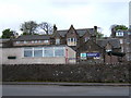
2
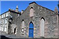
Port Bannatyne Village Hall
Built c1843 at the Free Church
Image: © Leslie Barrie
Taken: 8 Jul 2013
0.01 miles
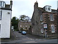
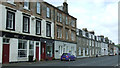
3
Duncan Street Port Bannatyne
From Marine Drive junction
Image: © John Firth
Taken: 12 May 2011
0.02 miles
4

Castle Street
Looking west from Stuart Street.
Image: © Thomas Nugent
Taken: 2 Jul 2018
0.03 miles
5
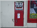
Port Bannatyne Post Office postbox
Here is the postbox, complete with keys.
Image: © Nick Mutton 01329 000000
Taken: 23 Feb 2008
0.03 miles
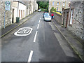
6
Marine Road, Port Bannatyne
Facing the sea, north of the post office.
Image: © Thomas Nugent
Taken: 13 Jun 2013
0.03 miles
7
North Bute Primary School, Port Bannatyne
Image: © Barbara Carr
Taken: 27 Apr 2009
0.04 miles
8

Marine Road, Port Bannatyne
Stuart Street is on the left.
Image: © Thomas Nugent
Taken: 2 Jul 2018
0.04 miles
9

Stuart Street
Off Marine Road, leads to Castle Street.
Image: © Thomas Nugent
Taken: 2 Jul 2018
0.04 miles
