IMAGES TAKEN NEAR TO
Mill Street, ISLE OF BUTE, PA20 0EX
Introduction
This page details the photographs taken nearby to Mill Street, PA20 0EX by members of the Geograph project.
The Geograph project started in 2005 with the aim of publishing, organising and preserving representative images for every square kilometre of Great Britain, Ireland and the Isle of Man.

There are currently over 7.5m images from over14,400 individuals and you can help contribute to the project by visiting https://www.geograph.org.uk
Image Map
Images are licensed for reuse under creativecommons.org/licenses/by-sa/2.0
Notes
- Clicking on the map will re-center to the selected point.
- The higher the marker number, the further away the image location is from the centre of the postcode.
Image Listing (220 Images Found)
Images are licensed for reuse under creativecommons.org/licenses/by-sa/2.0
Image
Details
Distance
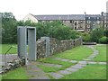
2
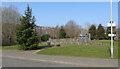
Lade Park
Opened in 2005 on the site of old mill related tenement buildings. Shown as "Mill Wheel park" on an information board within the park.
Image: © Thomas Nugent
Taken: 23 Mar 2022
0.03 miles
3
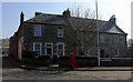
Colbeck Place
At the corner of Union Street and Russell Street. Category B Listed http://portal.historicenvironment.scot/designation/LB40460 .
Image: © Thomas Nugent
Taken: 23 Mar 2022
0.03 miles
4
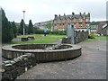
Rothesay Lade Park
The 'Water of Rothesay' stream was diverted to form the mill lade. Originally used for corn mills in the 16th Century it was later used for flax in the 17th Century. At the end of the 18th Century the mills in John Street were the first in Scotland to switch to cotton spinning. The mills saw their heyday in the 1880s when there were two spinning and three weaving mills.
Image: © John M
Taken: 29 Jun 2012
0.03 miles
5
Rothesay Lade Park
The 'Water of Rothesay' stream was diverted to form the mill lade. Originally used for corn mills in the 16th Century it was later used for flax in the 17th Century. At the end of the 18th Century the mills in John Street were the first in Scotland to switch to cotton spinning. The mills saw their heyday in the 1880s when there were two spinning and three weaving mills.
Image: © John M
Taken: 29 Jun 2012
0.03 miles
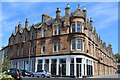
6
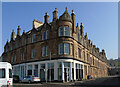
Mill Street at Russell Street
Mill Street is on the left, the B878 continues to the right as Russell Street (perhaps named after the building's architect Thomas Russell). Category B Listed http://portal.historicenvironment.scot/designation/LB40485 .
See also Image & Image
Image: © Thomas Nugent
Taken: 23 Mar 2022
0.04 miles
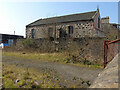
7
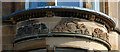
Building detail, Russell Street
Image: © Thomas Nugent
Taken: 23 Mar 2022
0.04 miles
8
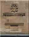
Building detail, Russell Street
The street name is carved into the stone. Category B Listed http://portal.historicenvironment.scot/designation/LB40485 .
See also Image & Image
Image: © Thomas Nugent
Taken: 23 Mar 2022
0.05 miles
9
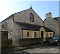
Former Gaelic Church, Rothesay
On Russell Street. See also Image
Canmore: https://canmore.org.uk/site/180877/bute-rothesay-russell-street-gaelic-church .
Image: © Thomas Nugent
Taken: 23 Mar 2022
0.05 miles
10
Former Gaelic Church, Rothesay
On Russell Street. See also Image
Canmore: https://canmore.org.uk/site/180877/bute-rothesay-russell-street-gaelic-church .
Image: © Thomas Nugent
Taken: 23 Mar 2022
0.05 miles