IMAGES TAKEN NEAR TO
Columshill Place, ISLE OF BUTE, PA20 0DL
Introduction
This page details the photographs taken nearby to Columshill Place, PA20 0DL by members of the Geograph project.
The Geograph project started in 2005 with the aim of publishing, organising and preserving representative images for every square kilometre of Great Britain, Ireland and the Isle of Man.

There are currently over 7.5m images from over14,400 individuals and you can help contribute to the project by visiting https://www.geograph.org.uk
Image Map
Images are licensed for reuse under creativecommons.org/licenses/by-sa/2.0
Notes
- Clicking on the map will re-center to the selected point.
- The higher the marker number, the further away the image location is from the centre of the postcode.
Image Listing (298 Images Found)
Images are licensed for reuse under creativecommons.org/licenses/by-sa/2.0
Image
Details
Distance
1
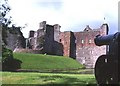
Rothesay Castle
Rothesay Castle has a long association with the Stewart kings of Scots. It stands on a mound surrounded by a moat, in the heart of the town.
Image: © Anne Burgess
Taken: Unknown
0.02 miles
2
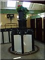
Victorian public convenience, Rothesay
Image: © Eileen Henderson
Taken: 25 Sep 2005
0.02 miles
4
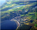
Rothesay and Loch Ascog from the air
Part of Loch Fad is also visible on the right.
Viewed from a Glasgow bound Boeing 747.
Image: © Thomas Nugent
Taken: 30 Jul 2007
0.02 miles
5
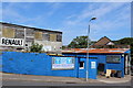
Rothesay Motor Services
Business premises on Ladeside Street
Image: © Leslie Barrie
Taken: 8 Jul 2013
0.06 miles
6
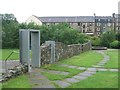
Rothesay Lade Park
The 'Water of Rothesay' stream was diverted to form the mill lade. Originally used for corn mills in the 16th Century it was later used for flax in the 17th Century. At the end of the 18th Century the mills in John Street were the first in Scotland to switch to cotton spinning. The mills saw their heyday in the 1880s when there were two spinning and three weaving mills.
Image: © John M
Taken: 29 Jun 2012
0.08 miles
7
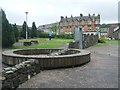
Rothesay Lade Park
The 'Water of Rothesay' stream was diverted to form the mill lade. Originally used for corn mills in the 16th Century it was later used for flax in the 17th Century. At the end of the 18th Century the mills in John Street were the first in Scotland to switch to cotton spinning. The mills saw their heyday in the 1880s when there were two spinning and three weaving mills.
Image: © John M
Taken: 29 Jun 2012
0.09 miles
8
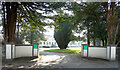
Entrance to Bute Fabrics
On Barone Road. See also Image & Image
Bute Fabrics web site: https://www.butefabricsltd.com/bute-collection .
Image: © Thomas Nugent
Taken: 23 Mar 2022
0.09 miles
9
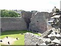
Rothesay Castle
View of the interior from the walls. There has been a castle here from earliest times and the present structure dates from the 13th to the 15th century. It was captured by the Vikings and not retaken until the Battle of Largs in 1263.
Now in the centre of the town it is surrounded by a deep moat in which there are a number of very large carp.
Image: © ronnie leask
Taken: 29 Jun 2007
0.09 miles
10
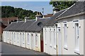
John Street, Rothesay
Single-storeyed houses built in 1825 by the Cotton Mill Society
Image: © Leslie Barrie
Taken: 8 Jul 2013
0.10 miles