IMAGES TAKEN NEAR TO
Drumshantie Road, GOUROCK, PA19 1SB
Introduction
This page details the photographs taken nearby to Drumshantie Road, PA19 1SB by members of the Geograph project.
The Geograph project started in 2005 with the aim of publishing, organising and preserving representative images for every square kilometre of Great Britain, Ireland and the Isle of Man.

There are currently over 7.5m images from over14,400 individuals and you can help contribute to the project by visiting https://www.geograph.org.uk
Image Map
Images are licensed for reuse under creativecommons.org/licenses/by-sa/2.0
Notes
- Clicking on the map will re-center to the selected point.
- The higher the marker number, the further away the image location is from the centre of the postcode.
Image Listing (248 Images Found)
Images are licensed for reuse under creativecommons.org/licenses/by-sa/2.0
Image
Details
Distance
1
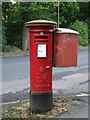
George 6th pillar box
On Drumshantie Road, Gourock.
Image: © Thomas Nugent
Taken: 5 Oct 2008
0.05 miles
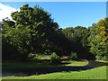
2
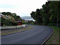
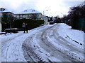
Drumshantie Road
Looking down the hill towards Broomberry Drive.
Image: © Thomas Nugent
Taken: 5 Oct 2008
0.05 miles
3
Craigmuschat Road
Off Drumshantie Road in Gourock.
Image: © Thomas Nugent
Taken: 5 Oct 2008
0.06 miles
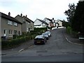
4
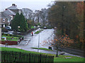
Drumshantie Road
The view is from near the junction with Craigmuschat Road. This area is shown from a distance in Image Behind the trees to the right of the road is Gourock Glen, the course of the Gourock Burn.
Image: © Lairich Rig
Taken: 10 Oct 2016
0.06 miles
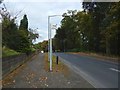
5
Fletcher Avenue
With Gourock High School just visible on the horizon.
Image: © Thomas Nugent
Taken: 6 Dec 2010
0.06 miles
6
Drumshantie Road
At the junction with Tower Drive. Viewed from Staffa Street.
Image: © Thomas Nugent
Taken: 4 Nov 2010
0.07 miles
7

Gourock
A leaf covered path leading to Park Terrace.
Image: © Thomas Nugent
Taken: 4 Nov 2013
0.08 miles
8
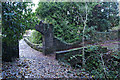
Park Terrace
Park Terrace is on the right, Darroch Avenue on the left. Off Broomberry Drive.
Image: © Thomas Nugent
Taken: 4 Nov 2013
0.08 miles
9
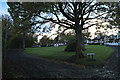
Gourock Park
Gourock Burn is on the right. The arch leads to the former stables.
Image: © Thomas Nugent
Taken: 4 Nov 2013
0.09 miles
10
The former site of Gourock Castle
See https://canmore.org.uk/site/41325 at Canmore for further details. As noted there, this castle was pulled down in the middle of the eighteenth century, and no trace of the building remains.
A later Gourock Castle, located elsewhere, is likewise gone, its former site now occupied by Image
Image: © Lairich Rig
Taken: 24 Sep 2018
0.09 miles