IMAGES TAKEN NEAR TO
Larch Walk, WEMYSS BAY, PA18 6BJ
Introduction
This page details the photographs taken nearby to Larch Walk, PA18 6BJ by members of the Geograph project.
The Geograph project started in 2005 with the aim of publishing, organising and preserving representative images for every square kilometre of Great Britain, Ireland and the Isle of Man.

There are currently over 7.5m images from over14,400 individuals and you can help contribute to the project by visiting https://www.geograph.org.uk
Image Map
Images are licensed for reuse under creativecommons.org/licenses/by-sa/2.0
Notes
- Clicking on the map will re-center to the selected point.
- The higher the marker number, the further away the image location is from the centre of the postcode.
Image Listing (105 Images Found)
Images are licensed for reuse under creativecommons.org/licenses/by-sa/2.0
Image
Details
Distance
1
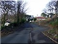
Cliff Terrace Road
At the junction with Wallace Road.
Image: © Thomas Nugent
Taken: 1 Jan 2009
0.08 miles
2
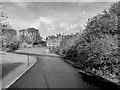
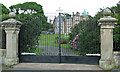
Dunloe House
Dunloe House. Scots Baronial mansion house built in 1862.
Category B-listed.
Image: © Raibeart MacAoidh
Taken: 22 Feb 2017
0.08 miles
3
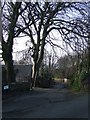
Wallace Road
At the junction with Cliff Terrace Road.
Image: © Thomas Nugent
Taken: 1 Jan 2009
0.10 miles
4
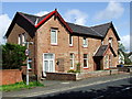
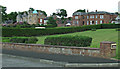
Woodside
By the A78 at the north end of Wemyss Bay.
Image: © Thomas Nugent
Taken: 21 May 2007
0.10 miles
5
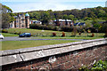
Dunloe
A large house by the sea on Wemyss Bay Road. Category B Listed Dunloe http://data.historic-scotland.gov.uk/pls/htmldb/f?p=2200:15:0::::BUILDING:48936 is largely the work of architect John Honeyman http://www.scottisharchitects.org.uk/architect_full.php?id=200245 . This area was known as New Glasgow in the late 19th Century.
Image: © Thomas Nugent
Taken: 13 Jun 2013
0.10 miles
6

Dunloe
A large house by the sea on Wemyss Bay Road. Category B Listed Dunloe http://data.historic-scotland.gov.uk/pls/htmldb/f?p=2200:15:0::::BUILDING:48936 is largely the work of architect John Honeyman http://www.scottisharchitects.org.uk/architect_full.php?id=200245 . This area was known as New Glasgow in the late 19th Century.
See also Image
Image: © Thomas Nugent
Taken: 13 Jun 2013
0.10 miles
7
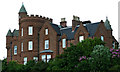
Dunloe and Mansfield
Two grand villas, built in 1862 for wealthy Glasgow merchants. Category B Listed buildings http://data.historic-scotland.gov.uk/pls/htmldb/f?p=2200:15:0::::BUILDING:48936 on Wemyss Bay Road.
Image: © Thomas Nugent
Taken: 16 May 2015
0.11 miles
8
The Cliff
By Architect John Honeyman http://www.scottisharchitects.org.uk/architect_full.php?id=200245 , one of over twenty Wemyss Bay buildings designed by him.
Image: © Thomas Nugent
Taken: 13 Jun 2013
0.11 miles
9

Wemyss Bay From The Ferry Terminal
The chimney of the defunct Inverkip Power Station dominates the skyline in this view of Wemyss Bay from the deck of the Caledonian MacBrayne vessel 'Isle Of Arran' berthed at the ferry terminal.
Image: © James T M Towill
Taken: 22 Sep 2012
0.11 miles
10
Dunloe, Mansfield and Redholm
Large houses by the sea on Wemyss Bay Road. Category B Listed Dunloe http://data.historic-scotland.gov.uk/pls/htmldb/f?p=2200:15:0::::BUILDING:48936 , on the left, is largely the work of architect John Honeyman http://www.scottisharchitects.org.uk/architect_full.php?id=200245 . This area was known as New Glasgow in the late 19th Century.
Image: © Thomas Nugent
Taken: 13 Jun 2013
0.11 miles