IMAGES TAKEN NEAR TO
Auchneagh Avenue, GREENOCK, PA16 9EP
Introduction
This page details the photographs taken nearby to Auchneagh Avenue, PA16 9EP by members of the Geograph project.
The Geograph project started in 2005 with the aim of publishing, organising and preserving representative images for every square kilometre of Great Britain, Ireland and the Isle of Man.

There are currently over 7.5m images from over14,400 individuals and you can help contribute to the project by visiting https://www.geograph.org.uk
Image Map
Images are licensed for reuse under creativecommons.org/licenses/by-sa/2.0
Notes
- Clicking on the map will re-center to the selected point.
- The higher the marker number, the further away the image location is from the centre of the postcode.
Image Listing (57 Images Found)
Images are licensed for reuse under creativecommons.org/licenses/by-sa/2.0
Image
Details
Distance
1

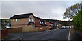
Old Inverkip Road bungalows
Between Delfie Drive and Inverkip Road.
Image: © Thomas Nugent
Taken: 10 May 2016
0.03 miles
2

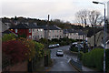
Old Inverkip Road
At Harrier Way, which is on the left.
Image: © Thomas Nugent
Taken: 10 May 2016
0.05 miles
3

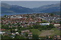
Auchneagh Road & Wren Road from Greenock Cut
Auchneagh Road continues straight uphill onto Wren Road in the Fancy Farm housing scheme. The brown building with the tall chimney is Greenock Hospital Laundry which is earmarked for closure. The River Clyde and Argyll hills can be seen in the distance.
Image: © Thomas Nugent
Taken: 17 Apr 2008
0.05 miles
4
Old Inverkip Road
At Harrier Way, which was built on the site of the Wellpark Harriers running club house.
Image: © Thomas Nugent
Taken: 8 Nov 2012
0.05 miles
5
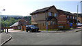
Harrier Way
Built on the site of the Wellpark Harriers running club house.
Image: © Thomas Nugent
Taken: 10 May 2016
0.06 miles
6
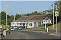
The A78 Inverkip Road
Phillips Garage is a well known local landmark at the entrance to the Pennyfern housing scheme.
Image: © Thomas Nugent
Taken: 10 Jul 2013
0.09 miles
8

Rankin Park Bowling Club gate
A small sky sign, bearing the date 1922. On Inverkip Road.
Image: © Thomas Nugent
Taken: 17 Apr 2016
0.11 miles
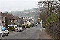
9
Old Inverkip Road
Looking towards Gateside Avenue from Harrier Way.
Image: © Thomas Nugent
Taken: 8 Nov 2012
0.11 miles
10
Southwest Greenock from Greenock Cut
The brownfield site in the lower right corner is the site of the former Greenock Hospitals Laundry.
Image: © Thomas Nugent
Taken: 2 Jun 2013
0.11 miles