IMAGES TAKEN NEAR TO
Brachelston Street, GREENOCK, PA16 9AD
Introduction
This page details the photographs taken nearby to Brachelston Street, PA16 9AD by members of the Geograph project.
The Geograph project started in 2005 with the aim of publishing, organising and preserving representative images for every square kilometre of Great Britain, Ireland and the Isle of Man.

There are currently over 7.5m images from over14,400 individuals and you can help contribute to the project by visiting https://www.geograph.org.uk
Image Map
Images are licensed for reuse under creativecommons.org/licenses/by-sa/2.0
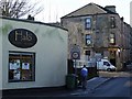
Notes
- Clicking on the map will re-center to the selected point.
- The higher the marker number, the further away the image location is from the centre of the postcode.
Image Listing (264 Images Found)
Images are licensed for reuse under creativecommons.org/licenses/by-sa/2.0
Image
Details
Distance
1
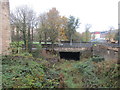
Course of the former Greenock and Ayrshire Railway
Passing beneath Inverkip Road.
This was once an important route to Greenock Princes Pier. The line opened to passenger trains in 1869 and closed in 1965. However container trains ran for a number of years until the final closure of the line in 1991.
Image: © Jonathan Thacker
Taken: 31 Oct 2017
0.03 miles
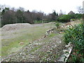
2
Princes Pier railway line
The now disused line runs mostly through tunnels from Mearns Street to Princes Pier. This view from the bridge at Orangefield is looking towards the tunnel that runs underneath Greenock Cemetery gates and the west end. See also Image
Image: © Thomas Nugent
Taken: 23 Nov 2007
0.03 miles
3
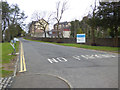
Greenock Cemetery drive
At the main entrance at South Street roundabout.
Image: © Thomas Nugent
Taken: 30 Mar 2018
0.04 miles
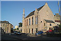
4
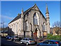
Orangefield Baptist Church
At Orangefield.
Image: © Thomas Nugent
Taken: 5 Mar 2007
0.04 miles
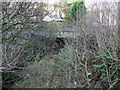
5
Orangefield railway bridge
Carries Old Inverkip Road over the disused Princes Pier line.
Image: © Thomas Nugent
Taken: 11 Feb 2009
0.05 miles
6
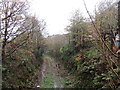
Course of the former Greenock and Ayrshire Railway
Was once an important route to Greenock Princes Pier. The line opened to passenger trains in 1869 and closed in 1965. However container trains ran for a number of years until the final closure of the line in 1991.
Image: © Jonathan Thacker
Taken: 31 Oct 2017
0.05 miles
7
Site of McNeil Baths
Between Brachelston Street and the A78 Inverkip Road. See Image] for details.
Image: © Thomas Nugent
Taken: 27 Jan 2007
0.05 miles
8
Former Orangefiled Baptist Church
Now a dance studio and restaurant.
Image: © Thomas Nugent
Taken: 10 Jul 2013
0.05 miles
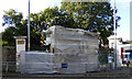
9
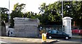
Greenock Cemetery Gates renovation
The ironwork was encapsulated during shot-blasting and repainting, possibly due to the presence of old lead paint.
Image: © Thomas Nugent
Taken: 14 Sep 2017
0.06 miles
10
Greenock Cemetery Gates renovation
The ironwork was encapsulated during shot-blasting and repainting, possibly due to the presence of old lead paint.
Image: © Thomas Nugent
Taken: 14 Sep 2017
0.06 miles