IMAGES TAKEN NEAR TO
Eldon Street, GREENOCK, PA16 7SA
Introduction
This page details the photographs taken nearby to Eldon Street, PA16 7SA by members of the Geograph project.
The Geograph project started in 2005 with the aim of publishing, organising and preserving representative images for every square kilometre of Great Britain, Ireland and the Isle of Man.

There are currently over 7.5m images from over14,400 individuals and you can help contribute to the project by visiting https://www.geograph.org.uk
Image Map (Loading...)


Getting Data...Please wait
Leaflet Map data © OpenStreetMap
Images are licensed for reuse under creativecommons.org/licenses/by-sa/2.0
Notes
- Clicking on the map will re-center to the selected point.
- The higher the marker number, the further away the image location is from the centre of the postcode.
Image Listing (90 Images Found)
Images are licensed for reuse under creativecommons.org/licenses/by-sa/2.0
Image
Details
Distance
1
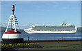
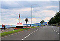
Crown Princess off Greenock
Crown Princess is a regular summer visitor to Greenock Ocean Terminal. Seen here passing Greenock Esplanade a few minutes after departing the quay at GOT. The Esplanade was thronged with several hundred on-lookers - none of whom can be seen in the photo.
The Buoy was the first flashing buoy used to aid navigation Image
Image: © Thomas Nugent
Taken: 23 Jul 2010
0.02 miles
2
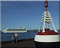
Crown Princess off Greenock
Passing the buoy on Greenock Esplanade Image
Image: © Thomas Nugent
Taken: 23 Jul 2010
0.02 miles
3
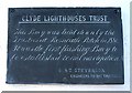
Plaque on buoy
At Greenock Esplanade. See Image
Image: © Thomas Nugent
Taken: 6 Mar 2007
0.02 miles
4
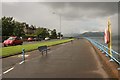
Esplanade, Greenock
Looking west-northwest.
Image: © Richard Sutcliffe
Taken: 3 Aug 2017
0.05 miles
6
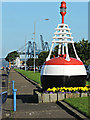
Buoy on Greenock Esplanade
A plaque on the buoy reads 'Clyde Lighthouses Trust. This buoy was laid down by the Trustees at Rosneath Patch in 1880. It was the first flashing buoy to be established to aid navigation. D & T Stevenson, Engineers to the Trustees.'
Unfortunately, the cycle path planner did not make allowances for bypassing the buoy.
Image: © Thomas Nugent
Taken: 16 Aug 2015
0.05 miles
7
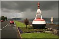
Old navigation buoy, Esplanade, Greenock
A squall is fast approaching down the Clyde from the west.
There is a plaque on the river side of the buoy, which reads:
CLYDE LIGHTHOUSES TRUST
This buoy was laid down by the
Trustees at Rosneath Patch in 1880
It was the first flashing buoy to
be established to aid navigation
D & T Stevenson
Engineers to the Trustees
Image: © Richard Sutcliffe
Taken: 3 Aug 2017
0.05 miles
8
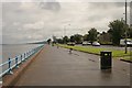
Esplanade, Greenock
Looking southeast.
Image: © Richard Sutcliffe
Taken: 3 Aug 2017
0.05 miles
9
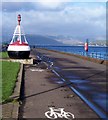
Marker Buoy
On National Cycle Route 75 at Greenock Esplanade. There can't be many cycle paths with a marine navigation buoy in the middle! See Image] for more information.
Image: © Thomas Nugent
Taken: 6 Mar 2007
0.06 miles
10
Navigation buoy
On a cycle path on Greenock Esplanade. See also Image Kilcreggan on the Rosneath Peninsula can be seen across the Clyde.
Image: © Thomas Nugent
Taken: 7 Jan 2008
0.06 miles