IMAGES TAKEN NEAR TO
Finch Road, GREENOCK, PA16 7DG
Introduction
This page details the photographs taken nearby to Finch Road, PA16 7DG by members of the Geograph project.
The Geograph project started in 2005 with the aim of publishing, organising and preserving representative images for every square kilometre of Great Britain, Ireland and the Isle of Man.

There are currently over 7.5m images from over14,400 individuals and you can help contribute to the project by visiting https://www.geograph.org.uk
Image Map
Images are licensed for reuse under creativecommons.org/licenses/by-sa/2.0
Notes
- Clicking on the map will re-center to the selected point.
- The higher the marker number, the further away the image location is from the centre of the postcode.
Image Listing (100 Images Found)
Images are licensed for reuse under creativecommons.org/licenses/by-sa/2.0
Image
Details
Distance
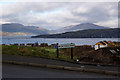
2
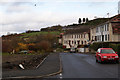
Lyle Hill
Viewed from the Greenock Cut, Lyle Hill is in the foreground, the hills in the distance are in Argyll. Rosneath TV transmitter can be seen to the right.
Image: © Thomas Nugent
Taken: 10 Aug 2009
0.05 miles
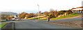
3
Grieve Road
Viewed from the Lyle Road junction.
Image: © Thomas Nugent
Taken: 18 Aug 2008
0.05 miles
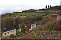
4
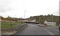
Finch Road
Lyle Road is in the left distance.
Image: © Thomas Nugent
Taken: 8 Nov 2012
0.05 miles
5
Lyle Road from Finch Road
The houses in the foreground are on Merlin Avenue.
Image: © Thomas Nugent
Taken: 8 Nov 2012
0.05 miles
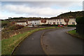
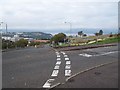
6
Lyle Road
The confusing road layout at the junction with Grieve Road.
Image: © Thomas Nugent
Taken: 17 Nov 2018
0.06 miles
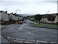
7
Finch Road
The sign points to number 20, which no longer exists. The Cowal Peninsula is in the left distance, the Rosneath Peninsula is in the right distance, with the Firth of Clyde between. The playing field is at Clydeview Academy.
Image: © Thomas Nugent
Taken: 8 Nov 2012
0.06 miles
8
Finch Road
The sign points to number 20, which no longer exists. The Cowal Peninsula is in the left distance, the Rosneath Peninsula is in the right distance, with the Firth of Clyde between.
Image: © Thomas Nugent
Taken: 8 Nov 2012
0.06 miles
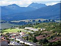
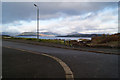
10
Road Junction top of Lyle Hill
River Clyde in the background
Image: © william craig
Taken: 14 Oct 2005
0.08 miles