IMAGES TAKEN NEAR TO
Raven Road, GREENOCK, PA16 7BW
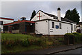
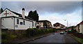
Introduction
This page details the photographs taken nearby to Raven Road, PA16 7BW by members of the Geograph project.
The Geograph project started in 2005 with the aim of publishing, organising and preserving representative images for every square kilometre of Great Britain, Ireland and the Isle of Man.

There are currently over 7.5m images from over14,400 individuals and you can help contribute to the project by visiting https://www.geograph.org.uk
Image Map
Images are licensed for reuse under creativecommons.org/licenses/by-sa/2.0
Notes
- Clicking on the map will re-center to the selected point.
- The higher the marker number, the further away the image location is from the centre of the postcode.
Image Listing (29 Images Found)
Images are licensed for reuse under creativecommons.org/licenses/by-sa/2.0
Image
Details
Distance
1
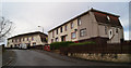
Sandpiper Lane
New houses off Grieve Road.
Image: © Thomas Nugent
Taken: 8 Aug 2012
0.08 miles
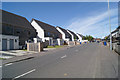
2
Grieve Road
Timber clad houses near the shops.
Image: © Thomas Nugent
Taken: 10 May 2016
0.10 miles
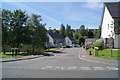
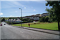
3
Grieve Road
Looking up the hill towards Lyle Road.
Image: © Thomas Nugent
Taken: 8 Aug 2012
0.12 miles
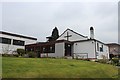
4
St Margaret's Church
Church of Scotland on Finch Road.
Image: © Thomas Nugent
Taken: 8 Nov 2012
0.13 miles
5
St Margaret's Church
Church of Scotland on Finch Road, viewed from Auchneagh Farm Road.
Image: © Thomas Nugent
Taken: 8 Nov 2012
0.13 miles
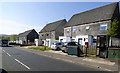
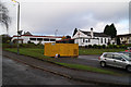
7
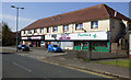
Grieve Road shops
A short row of shops with flats above.
Image: © Thomas Nugent
Taken: 10 May 2016
0.14 miles
8
Finch Road
St Margaret's Church of Scotland is on the left.
Image: © Thomas Nugent
Taken: 8 Nov 2012
0.15 miles
9
Grieve Road
Looking south towards Linnet Road.
Image: © Thomas Nugent
Taken: 8 Aug 2012
0.16 miles