IMAGES TAKEN NEAR TO
Angus Road, GREENOCK, PA16 0PD
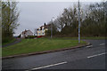
Introduction
This page details the photographs taken nearby to Angus Road, PA16 0PD by members of the Geograph project.
The Geograph project started in 2005 with the aim of publishing, organising and preserving representative images for every square kilometre of Great Britain, Ireland and the Isle of Man.

There are currently over 7.5m images from over14,400 individuals and you can help contribute to the project by visiting https://www.geograph.org.uk
Image Map (Loading...)


Getting Data...Please wait
Leaflet Map data © OpenStreetMap
Images are licensed for reuse under creativecommons.org/licenses/by-sa/2.0
Notes
- Clicking on the map will re-center to the selected point.
- The higher the marker number, the further away the image location is from the centre of the postcode.
Image Listing (29 Images Found)
Images are licensed for reuse under creativecommons.org/licenses/by-sa/2.0
Image
Details
Distance
1
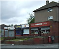
Shops on Angus Road
At the corner of Banff Road.
Image: © Thomas Nugent
Taken: 23 Jun 2008
0.04 miles
2
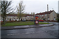
Burns Road
A small Square on Burns Road, near Burns Square.
Image: © Thomas Nugent
Taken: 23 Apr 2010
0.08 miles
3
Burns Road
Looking towards Burns Square from near Banff Road.
Image: © Thomas Nugent
Taken: 23 Jun 2008
0.08 miles
4
Fife Road
At the Banff Road end of the street.
Image: © Thomas Nugent
Taken: 23 Jun 2008
0.11 miles
5
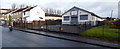
Lothian Road
Larkfield Housing office on the right.
Image: © Thomas Nugent
Taken: 9 Mar 2020
0.12 miles
6
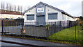
Larkfield Housing Office
On Lothian Road, off Burns Road.
Image: © Thomas Nugent
Taken: 9 Mar 2020
0.12 miles
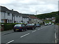
7
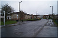
Banff Road
In the Larkfield housing scheme.
Image: © Thomas Nugent
Taken: 23 Apr 2010
0.12 miles
8
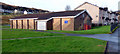
Larkfield Community Hall
On Lothian Road at Burns Road.
Image: © Thomas Nugent
Taken: 9 Mar 2020
0.14 miles
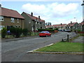
9
Earnhill Road
The houses are on Fife Road.
Image: © Thomas Nugent
Taken: 23 Apr 2010
0.14 miles
10
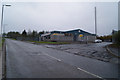
Inverclyde Taxis
Taxi depot and office on Earnhill Road.
Image: © Thomas Nugent
Taken: 23 Apr 2010
0.17 miles