IMAGES TAKEN NEAR TO
Aberdour Place, GREENOCK, PA16 0HZ
Introduction
This page details the photographs taken nearby to Aberdour Place, PA16 0HZ by members of the Geograph project.
The Geograph project started in 2005 with the aim of publishing, organising and preserving representative images for every square kilometre of Great Britain, Ireland and the Isle of Man.

There are currently over 7.5m images from over14,400 individuals and you can help contribute to the project by visiting https://www.geograph.org.uk
Image Map
Images are licensed for reuse under creativecommons.org/licenses/by-sa/2.0
Notes
- Clicking on the map will re-center to the selected point.
- The higher the marker number, the further away the image location is from the centre of the postcode.
Image Listing (177 Images Found)
Images are licensed for reuse under creativecommons.org/licenses/by-sa/2.0
Image
Details
Distance
1
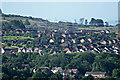
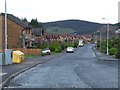
Hill Farm housing estates
Viewed from Bargane Hill. The wind turbine near Kelly Mains Farm is a recent addition to the horizon.
Image: © Thomas Nugent
Taken: 25 Aug 2013
0.03 miles
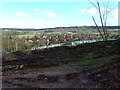
2
Hill Farm housing estate
Viewed from Berfern Plantation. Everton Farm can be seen on the hill in the distance.
Image: © Thomas Nugent
Taken: 7 Oct 2011
0.03 miles
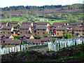
3
Berfern Plantation
Much of the plantation has been felled recently, with some new saplings planted, but there are still large open areas where mature trees stood until recently.
Image: © Thomas Nugent
Taken: 7 Oct 2011
0.03 miles
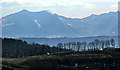
4
Arran from Idzholm Hill
With the Hill Farm housing estates in the foreground.
Image: © Thomas Nugent
Taken: 1 Apr 2013
0.03 miles
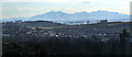
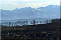
5
Arran from Idzholm Hill
The replanted Berfern Plantation is in the foreground.
Image: © Thomas Nugent
Taken: 1 Apr 2013
0.03 miles
6
Arran from Idzholm Hill
The replanted Berfern Plantation is in the foreground.
Image: © Thomas Nugent
Taken: 1 Apr 2013
0.03 miles
7
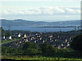
Ardgowan View
Housing estate south of the railway line in Inverkip. Toward Point and Rothesay are visible in the distance.
Image: © Thomas Nugent
Taken: 17 Jul 2008
0.04 miles
8
Ardgowan View housing estate
With Cauldron Hill, near Loch Thom, in the distance.
Image: © Thomas Nugent
Taken: 7 Nov 2008
0.05 miles
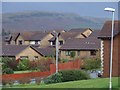
9
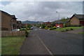
Cullen Crescent
Near the junction with Spey Road. Bargane Hill is on the horizon.
Image: © Thomas Nugent
Taken: 5 Dec 2008
0.06 miles
10
Cullen Crescent
At the junction with Findhorn Road.
Image: © Thomas Nugent
Taken: 10 Jun 2012
0.07 miles