IMAGES TAKEN NEAR TO
Langhill Road, GREENOCK, PA16 0DJ
Introduction
This page details the photographs taken nearby to Langhill Road, PA16 0DJ by members of the Geograph project.
The Geograph project started in 2005 with the aim of publishing, organising and preserving representative images for every square kilometre of Great Britain, Ireland and the Isle of Man.

There are currently over 7.5m images from over14,400 individuals and you can help contribute to the project by visiting https://www.geograph.org.uk
Image Map (Loading...)


Getting Data...Please wait
Leaflet Map data © OpenStreetMap
Images are licensed for reuse under creativecommons.org/licenses/by-sa/2.0
Notes
- Clicking on the map will re-center to the selected point.
- The higher the marker number, the further away the image location is from the centre of the postcode.
Image Listing (63 Images Found)
Images are licensed for reuse under creativecommons.org/licenses/by-sa/2.0
Image
Details
Distance
1
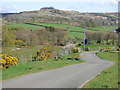
Langhill Farm
The start of the track leading from Millhouse Road.
Image: © Thomas Nugent
Taken: 5 Jul 2007
0.01 miles
2
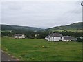
View from above Langhill Farm
looking towards Greenock
Image: © william craig
Taken: 16 Aug 2005
0.02 miles
3

Langhill Farm
With Dunrod Hill in the distance.
Image: © Thomas Nugent
Taken: 10 Jun 2012
0.02 miles
4
Dunrod Hill
Dunrod Hill (298m) is the peak on the right, Cauldron Hill (286m) is on the left. These form the north side of Shielhill Glen.
Image: © Thomas Nugent
Taken: 30 Apr 2018
0.04 miles
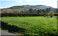
5
Bargane Hill
Viewed from the track at Langhill Farm.
Image: © Thomas Nugent
Taken: 30 Apr 2018
0.05 miles
6
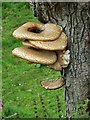
Fungus on dead tree
Each ring of fungus (Polyporous squamosus or Dryad's saddle) is about the size of a dinner plate. See the tree here Image
Image: © Thomas Nugent
Taken: 5 Jul 2007
0.06 miles
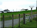
7
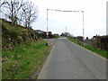
Power line warning gauge
A temporary structure at Langhill to warn drivers of vehicles involved in the removal of the pylon lines in Leapmoor Forest of the presence of active power lines in the area.
Image: © Thomas Nugent
Taken: 10 Apr 2020
0.06 miles
8
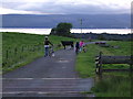
Cycling hazards
One of five cattle grids on this short stretch of road above Langhill Farm is not the only obstacle for these cyclists. The River Clyde and the Cowal peninsula are visible in the distance.
Image: © Thomas Nugent
Taken: 17 Jul 2008
0.07 miles
9
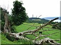
(Almost) Dead Tree
By the track leading to Langhill Farm. Commoncraig and Inverkip Power Station chimney are in the distance.
See the large fungus on this tree at Image
Image: © Thomas Nugent
Taken: 5 Jul 2007
0.07 miles
10
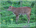
A wee coo
The same wee coo as seen here Image
Image: © Thomas Nugent
Taken: 17 Jul 2008
0.07 miles