IMAGES TAKEN NEAR TO
Langhouse Road, GREENOCK, PA16 0BJ
Introduction
This page details the photographs taken nearby to Langhouse Road, PA16 0BJ by members of the Geograph project.
The Geograph project started in 2005 with the aim of publishing, organising and preserving representative images for every square kilometre of Great Britain, Ireland and the Isle of Man.

There are currently over 7.5m images from over14,400 individuals and you can help contribute to the project by visiting https://www.geograph.org.uk
Image Map
Images are licensed for reuse under creativecommons.org/licenses/by-sa/2.0
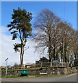
Notes
- Clicking on the map will re-center to the selected point.
- The higher the marker number, the further away the image location is from the centre of the postcode.
Image Listing (411 Images Found)
Images are licensed for reuse under creativecommons.org/licenses/by-sa/2.0
Image
Details
Distance
1
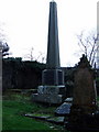
Grave of William Steele Brown
Locomotive Superintendent of the Edinburgh & Glasgow Railway. See Image] for details of the inscription. Located within the old graveyard.
Image: © Thomas Nugent
Taken: 11 Feb 2007
0.01 miles
2
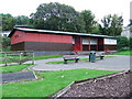
Inverkip Pavilion
A small community hall in the swingpark on Main Street.
Destroyed by a storm on 3rd January 2012 Image
Image: © Thomas Nugent
Taken: 30 Sep 2007
0.01 miles
3
Langhouse Road at Millhouse Road
The site of the original Inverkip Church.
Image: © Thomas Nugent
Taken: 6 Apr 2015
0.02 miles
4
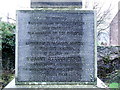
Obelisk inscription
See Image] for a view of the obelisk.
Image: © Thomas Nugent
Taken: 11 Feb 2007
0.02 miles
5
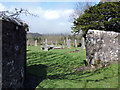
Old graveyard at Inverkip
On Millhouse Road, opposite the current cemetery.
Image: © Thomas Nugent
Taken: 6 Apr 2015
0.02 miles
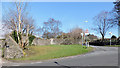
6
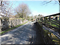
Millhouse Road
Inverkip Cemetery is on the right, the old cemetery is on the left.
Image: © Thomas Nugent
Taken: 6 Apr 2015
0.02 miles
7
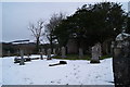
Old graveyard at Inverkip
On Millhouse Road at Langhouse Road, opposite the current cemetery.
Image: © Thomas Nugent
Taken: 28 Feb 2010
0.03 miles
8
Millhouse Road
The old graveyard is on the left side of Millhouse Road, the new one is on the right. Langhouse Road is in the foreground.
Image: © Thomas Nugent
Taken: 6 Nov 2011
0.03 miles
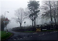
9
Millhouse Road
At the junction with Langhouse Road.
Image: © Thomas Nugent
Taken: 17 Apr 2020
0.03 miles
10

Swallow Brae housing estates
Viewed from Berfern Plantation.
Image: © Thomas Nugent
Taken: 15 Jun 2014
0.03 miles