IMAGES TAKEN NEAR TO
Mearns Street, GREENOCK, PA15 4PP
Introduction
This page details the photographs taken nearby to Mearns Street, PA15 4PP by members of the Geograph project.
The Geograph project started in 2005 with the aim of publishing, organising and preserving representative images for every square kilometre of Great Britain, Ireland and the Isle of Man.

There are currently over 7.5m images from over14,400 individuals and you can help contribute to the project by visiting https://www.geograph.org.uk
Image Map
Images are licensed for reuse under creativecommons.org/licenses/by-sa/2.0
Notes
- Clicking on the map will re-center to the selected point.
- The higher the marker number, the further away the image location is from the centre of the postcode.
Image Listing (629 Images Found)
Images are licensed for reuse under creativecommons.org/licenses/by-sa/2.0
Image
Details
Distance
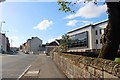
1
Shaw Place
At the bottom of Mearns Street, overlooking the town centre.
Image: © Thomas Nugent
Taken: 23 Nov 2007
0.00 miles
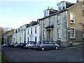
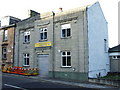
2
Shaw Place
Mearns Street is on the right.
Category B Listed buildings...
Nearest camera, No 5 http://data.historic-scotland.gov.uk/pls/htmldb/f?p=2200:15:0::::BUILDING:34147 .
Second building, No 4 http://data.historic-scotland.gov.uk/pls/htmldb/f?p=2200:15:0::::BUILDING:34146
Third building, No 3 http://data.historic-scotland.gov.uk/pls/htmldb/f?p=2200:15:0::::BUILDING:34145
Fourth building, No 2 http://data.historic-scotland.gov.uk/pls/htmldb/f?p=2200:15:0::::BUILDING:34144
Fifth building, No 1 http://data.historic-scotland.gov.uk/pls/htmldb/f?p=2200:15:0::::BUILDING:34143
Image: © Thomas Nugent
Taken: 10 Jul 2013
0.01 miles
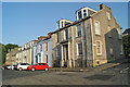
4
Greenock Morton Supporters Club
On Regent Street.
Image: © Thomas Nugent
Taken: 23 Nov 2007
0.03 miles
5
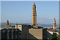
The Victoria Tower
The 245 feet high main tower on Greenock Town Hall. A Category A Listed building http://data.historic-scotland.gov.uk/pls/htmldb/f?p=2200:15:0::::BUILDING:34122 . Viewed from Shaw Place. The Mid Kirk church tower, which is also Category A Listed http://data.historic-scotland.gov.uk/pls/htmldb/f?p=2200:15:0::::BUILDING:34096 , is on the right.
Image: © Thomas Nugent
Taken: 10 Jul 2013
0.04 miles
7
Former Renfrewshire Bank building
On Bank Street, viewed from Shaw Place. A Category B Listed building http://data.historic-scotland.gov.uk/pls/htmldb/f?p=2200:15:0::::BUILDING:34090 .
Image: © Thomas Nugent
Taken: 10 Jul 2013
0.05 miles
8
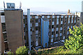
Greenock telephone exchange
A large exchange by the railway line at King Street.
Image: © Thomas Nugent
Taken: 10 Jul 2013
0.05 miles
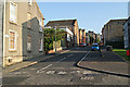
9
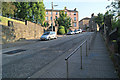
Bank Street
Looking up the hill from the steps to Clyde Square.
Image: © Thomas Nugent
Taken: 10 Jul 2013
0.05 miles